Quantcast
Channel: Cebu adventure – Adrenaline Romance
Viewing all 25 articles
Browse latest View live

Osmeña Peak: Love at First Climb

$
0
0

“So, are we going to share a single tent?” she asked me.

“Yes,” I replied, “but don’t worry. I’m harmless. In mountaineering, sharing a tent is for practicality.”

“Ah, okay,” she replied with a smile.

Apparently, I realized later on that I was far from harmless. During our first mountaineering experience together at Osmeña Peak, Dalaguete, the purportedly highest point in the Cebu Island, we exchanged pre-marital vows. On May 12, 2012, 9:00 p.m., Sheila and I became official sweethearts sharing a passion for adventure.

I aptly dubbed that day a Valentine’s Climb considering that there were sweet couples who climbed the majestic 1,013 meter mountain with us. Sir Jigz, lead guide of Mt. Kanlaon, and his girlfriend Ma’am Efrylle, went with us from Day 1. It was their first time to climb the popular Osmeña Peak, and I was happy to guide them. We planned to do a traverse to Kawasan Falls in Matutinao, Badian, but since not one of us is familiar with the trail (and I’m horrible at memorizing trails), I asked my fellow EWIT mountaineer, Sir Peri, to guide us. He obliged and at 10 p.m., he, Ma’am Karen, and a few other EWIT mountaineers went with them.

I daresay it was an adventure-filled but romantic weekend with three couples (me and Sweetie, Sir Jigz and Ma’am Efrylle, and Sir Peri and Ma’am Karen) doing a classic 7-hour trek that traverses two municipalities, cutting across the width of the Cebu island.

After buying our supplies at Mantalongon market, we danced the cha-cha.

done1

After getting tired of our audience, we proceeded to the valley that precedes Osmeña Peak. That valley is dubbed as the Vegetable Basket of Cebu. Mantalongon’s high altitude and fertile land make it a perfect place for growing vegetables. To get to Osmeña Peak, we decided to cut across the valley and the farmlands.

done2

Those are bukags or vegetable baskets.  When filled to the brim, these baskets can weigh more than a hundreds pounds! Every day, farmers carry these baskets from their farms to the market. And the way they do it is torturous; a farmer secures the basket onto his head with a strap. It’s arduous, back-breaking, neck-wracking work as they walk up and down rocky, slippery mountain trails for several miles to sell their produce. We have high respect for them.

done3

We cut across the valley. If you notice, the soil exhibits a reddish tint in it, an indication that the earth is rich in irons. That huge landslide in the distance is the result of geological displacement brought about by the February 2012 earthquake.

done4

Three-quarters of the way. It was here when we suddenly remembered we weren’t able to buy Coke, our survival drink. Fortunately, Sir Jigz and Ma’am Efrylle brought a 1.5 liter Coke. Hehehe!

done

A beautiful white, untouched limestone cliff at the side of a road at the right side of the valley. Someday, we’ll do a survey and check if it can be bolted for rock climbing.

done

After an hour of relaxed walking, we reached the road. Beside that road is the trail to the summit and campground.

done

Lovely babes! That’s Sheila and Ma’am Efrylle.

done

Start of the ascent. This was also where I began impressing Sheila. hehehe.

done

Going up towards the summit and the campsite.

done

Almost there.

done

The grassy trail towards Osmeña Peak. Be careful here. A misstep to the left will find you tumbling down a slope.  Save yourself from injury and embarrassment by watching your step.

done

Spectacular sunset as viewed from Osmeña Peak’s campground. Seeing panoramas like this dissolves any thought or feeling of self-importance.

done

The sun began her slumber, leaving behind ethereal rays that cast mysterious shadows.

done

Night fell and the sounds of the night started to permeate through the cold mountain air.

done

After setting up our tents, we prepared our dinner. Now, here’s the thing. What do you get when you have two people—one, a top guide who prepares home-cooked meals and two, a single-mom who prepares gourmet meals—join forces? Well, what else? A sumptuous feast up there!

done

Our mouthwatering dinner. . . macaroni with Italian sauces, cheese and hotdogs, home-made lumpia shanghai, rice, fruits and Coke!

done

After dinner and clearing up our things, Sheila and I had time with each other while Sir Jigz and Ma’am Efrylle went to another dark corner.

done

It was during the night when fireflies witnessed our admittance of love for each other. Yes, you might think that it was pretty quick; after all, we’ve known each other for only a few weeks. However, we have so much in common that we’re practically versions of each other! And yes, I broke my promise of being harmless . . . partially.

done

Sir Peri, Ma’am Karen, and other EWIT mountaineers arrived at 10 p.m. After setting up their tents and having a few gulps of Tanduay, we all turned in to sleep.

The Tanduay got the best of us, and we missed the sunrise. We woke up to a foggy morning.

done

Then we prepared another delectable breakfast, consisting of scrambled eggs and mushrooms, leftover macaroni, skinless longganisa, crab and corn chowder, and fruits.

done

Done with breakfast, we cleaned the area and striked a pose.

done

I would love to spend each morning with a cup of cappuccino with you, sweetie! I love you! (Yes, we were drinking hot cappuccino).

done

Lovely ladies on Cebu’s highest campground.

done

We still have a long trek ahead of us, so we broke camp at around 7 a.m.

done

With our stuff safely stowed in our packs, we started a short, easy assault of Osmeña Peak.

done

The gorgeous view that greeted us when we arrived at the summit. A magnificent view like this makes you grateful that you’re alive to witness the wonders of Mother Nature. Those hilly karst formations are slimmer and rockier versions of Bohol’s Chocolate Hills.

done

Ma’am Karen and Sir Perry followed us a few meters back.

done

Lovebirds enjoying our highest treasure as much as we enjoyed theirs, Mt. Kanlaon.

done

Quick pose with the adventurers before leaving the Peak for Kawasan Falls in Matutinao, Badian.

done

On our way to Kawasan Falls, which is a good 7 hours away on a leisurely trek.

done

These hills appear like sentinels watching over us.

done

We told you this was a romantic Valentine’s Trek, right?

done

Sparkle trail. Beside that trail is a well-terraced cabbage path.

done

When you see this cliff, you will know that you’re 2 or 3 hours away from Kawasan Falls.

done

Cebu mountaineers call this segment the Half Moon due to the crescent shape of the slope. The Half Moon is fully exposed to the sun, making it extremely uncomfortable to traverse. But once you cross this segment, Kawasan Falls is just 30 minutes away.

done

After almost 7 hours of leisurely trekking, we finally arrived at Station 3 of Kawasan Falls. Ma’am Efrylle’s face shows our story better than words do.

done

We can’t wait to dip in that refreshing, cool water.

done

Crossing the rickety bamboo bridge is a heart-pounding experience for some.

done

Station 3 where you can dip in Mother Nature’s very own bathtub.

Our sexy, lovely, beautiful ladies who eat mountains, caves, cliffs, and trails for breakfast. That’s Sheila, Ma’am Efrylle, and Ma’am Karen.

After an hour of freshening up, we were clean and ready to go home.

done

Crossing a narrow bamboo bridge to Station 1. Maam Efrylle is holding her hair for balance? Is that possible?

done

Officially sweethearts! I love you, sweetie pie! May we have more adventures together.

All photos courtesy of Jigz Santiago, Efrylle Marcial, Leylander Romarate, and Romanslerz Tura.

Suggested Itinerary:

Day 1
11:00 AM – meet at Caltex gas station beside USJR, take Dalaguete-bound minibus
12:00 PM – ETD Cebu
3:30 PM – ETA Mantalongon Market, buy supplies
4:00 PM – Start trek from Market to foot of Osmeña Peak
5:00 PM – Arrival at first water source
5:30 PM – Arrive at campsite, set camp, and visit summit
7:00 PM – Dinner and socials

Day 2
5:00 AM – Wake up call
5:15 AM – Prepare breakfast
6:00 AM – Breakfast
6:00 AM – Break Camp
7:00 AM – ETD Osmeña Peak, Start trek to Kawasan Falls
11:00 AM – Arrive at second water source
12:00 PM – Lunch on Trail
3:00 PM – ETA Kawasan Falls Station 3, swimming
4:30 PM – Trek to Matutinao Bus Stop/Church
5:00 PM – Ride bus to Cebu City
8:00 PM – Back in Cebu City


Cantabaco: A Rock Climber’s Mecca in Cebu

$
0
0

done

Do you want to be engaged in a sport where only a handful of people can actually appreciate what you’re doing? Do you want to join a sport where you literally risk life and limb to achieve a goal? Do you want to join a sport where you don’t compete with anybody but yourself? If you do, Sheila and I then welcome you to the world of rock climbing.

Rock climbing is an extreme sport like skydiving, base jumping, or snowboarding in which the element of danger haunts you to excitement. It’s a sport where you either “get it” or you don’t. Specifically, you either want to climb a towering cliff or you don’t.

The idea of rock climbing is pretty straightforward. You try to climb from the ground to the top of a cliff, but that’s just the first thing. The second thing comes if you slip, lose your balance, and fall along the way. Because of the potential injury (or death) that may happen during a fall, a good deal of highly specialized equipment is required to catch you and postpone your meeting with your creator.

done

Rock climbing in the Philippines, admittedly, is almost an unknown sport. Try searching the web for rock climbing specifically in the Philippines, and you’d come up with just a few relevant results. There are no route guidebooks, comprehensive accounts, and how-tos. Food and accommodations hover on rudimentary.

However, what it does offer is exceptional climbing in a virgin paradise, and in the country, the best place to scramble up cliffs is in Cantabaco, a quaint countryside town in the city of Toledo in the island of Cebu. Here, you can find the best, whitest, cleanest, unspoiled limestone cliffs in Cebu. The cliff is exquisitely bolted for exceptional sport climbing. If you seek to challenge yourself, then rock climbing in Cantabaco is definitely for you.

To get to this adrenalin pumping place, you need to ride a Toledo-bound bus at the Cebu South Bus Terminal. Ask the driver to drop you off at the Lutopan junction. From there, you ride a habal-habal (motorcycle for hire) to Cantabaco.  A habal-habal ride is almost always mandatory in any adventure. If you go to Cantabaco via bus, you are going to have to ride these skinny motorcycles unless you want to walk for an hour under the hot sun.

done

Tell the driver to drop you off at the Silangan Chapel. From here, the magnificent limestone cliff of Cantabaco is visible from the road.

done

A peaceful, quiet community. You may find it strange that there are only a handful of local climbers at the Philippines’ best rock climbing site.

done

Raymund Daculan and Enie Yonson are the two best known guides in Cantabaco. Willard Elimino can also render guideship services for you. Raymund’s house is just a 1-minute walk from the Silangan chapel while Enie’s is a bit farther away. Willard’s is about 6 kilometers away from Cantabaco. The photo below shows Raymund’s awesome crib. The apartment with the red roof is actually a bed-and-breakfast for visiting climbers. Lots of foreigners and local climbers rent rooms there for several days. For a small fee, you can even ask the household to cook your meals for you. The bed-and-breakfast features amenities that are fit for adventurers who are trying not to blow a hole in their wallets. Such amenities include the basics: a toilet, a bathroom, a washing area, and an outside dining area.

done

Inside Raymund’s cool crib. It’s chock-full of climbing equipment and a cool, cool motorcycle.

done

If this is your first time to experience rock climbing, you probably don’t have climbing equipment. Worry not, fellow adventurer, for our guides have their own equipment that you can rent for a minimal fee.

done

All set? Got your harness and rock climbing shoes? What about ropes, quickdraws, and belay devices? Great! Let’s head to the crag. It’s just a 15-minute walk from the chapel.

done

On the way, you may want to buy your lunch so you won’t have to exit the crag and go back to the street again to buy food during noontime. I tell you, you wouldn’t want to go down while you are in the heat of climbing; the adrenaline rush is just too strong that it overshadows your pangs of hunger. There are lots of carenderias (streetside eateries) around where you can take your pick.

done

A few minutes from the road, you will need to cross this rickety bamboo bridge that runs over a stream. Don’t worry, it’s strong although you might want to have a bit of malicious fun by shaking the bridge with your feet while someone crosses it. The bridge creaks and groans as you cross it, enhancing the rural, provincial feel. This bridge is actually a landmark in Cebu’s rock climbing community.

Turn left and follow the trail until you arrive at a small house. You pay a P5 entrance fee and log in your name.

done

After logging in, you need to follow a short trail through the jungle . . .

done

. . . then to the massive, magnificent, unspoiled limestone crag of Cantabaco.

done

Unless you are taking an alternative trail, the main trail takes you to Areas 1 and 2 where you can start climbing some routes. However, guides usually go directly to Area 3 where there is a lot of shade. To get to Area 3, you need to scramble up these huge, mossy, slippery boulders.

done

Welcome to Area 3 of Cantabaco. It offers a lot of shade while you come face-to-face with a fine limestone cliff.

done

On a good day, Area 3 may be filled with people. Don’t worry. There are 60 routes of varying climbing grades (level of difficulty) along the length of the crag.

done

Before we do anything, Sweetie and I usually head off to a nice nook in Area 3 where we can set up our hammock so that we can simply rest and snooze off if we run out of adrenaline, which is actually unlikely.

done

While you psyche up yourself or do some warm-ups, the guides prepare themselves to set up a route for you to climb.

done

First, we set up a top-rope system for you. To do that, we do a climbing technique called lead climbing. Lead climbing is ascending a route that involves a climber attaching himself or herself to a length of dynamic rope. As the climber ascends a route, he or she places protection equipment (pro, in short. In sport climbing, we use quickdraws as pro) to bolted hangers on the face of the route and clipping the rope to the pro. If the climber falls, the pro prevents him from plunging to his death.

done

Here, I’m lead climbing a route called Bohemian, my favorite warm-up route. See that orange thingy where the rope passed through and the similar blue object at the right side of my head? Those are quickdraws, or pro, to save me from a fall.

done

A climber needs another person below to hold the rope if he or she falls. That person also feeds rope as the lead climber ascends. This person is called a belayer, and your belayer literally has your life in his or her hands. It is important that your belayer knows how to do his job properly. It’s also important for the belayer to be calm and composed. Sweetie is my climbing partner and trusted belayer. The bond between Sweetie and me definitely becomes stronger as we entrust each other’s lives. Rock climbing allows us to experience that awesome responsibility.

done

That’s Sheila and some of our friends, belaying a few climbers in Area 2.

done

As the climber reaches the top of the route, he or she sets up an anchor so that the belayer can lower the climber down. Once the climber is down, you can now climb the route with the rope set up on an anchor high above the route. This type of climbing is called top roping. It’s a style of climbing in which a rope runs from a belayer at the foot of the route to an anchor system at the top of the route. The rope then goes back to the climber, tied through a harness that is worn by the climber.

Here, Sweetie is top roping the route I just climbed while I belayed her.

done

A few of Sweetie’s climbs.

done

One of Sweetie’s winning forms as she negotiates a route.

done

Sweetie high up on a route called Ninja Cools.

done

After completing a route, she comes back down and disengages himself. It’s your turn!

To give you an idea of the scale of the crag, check the photo below, and compare the size of the people to the rock. That is just the bottom of the cliff, not even 1/4th of the way!

done

Sir Tiki is almost at the top of the route.

done

Once you reach the top, you kiss the anchor (this is customary for first ascents) and look down. Yes, at a hundred feet, the view below is pretty scary! But the feeling of accomplishment is beyond words.

done

Once everyone has climbed the route, it’s time to clean the route, or retrieve all the quickdraws and the anchor. You don’t want to leave those expensive pieces of equipment, do you? Sweetie usually does the route cleaning. She climbs up the route and unclips all the quickdraws.

done

Nearing the top of the route . . .

done

. . . and finally reaching the anchor.

done

Sweetie prepares to anchor herself in order to set up a rappel anchor. Rappeling is one of the two ways that the retriever uses to go down. Retrieval/cleaning a route is the most crucial part of the climbing process. A mistake in the retrieval/cleaning process can actually injure or kill the climber.

done

Sweetie at work a hundred feet up!

done

Once she’s done, she can then rappel down.

done

Smile!

done

On the ground at last! Nice work, Sweetie!

done

Sometimes, you might want to take a break or climb other routes. You’re free to do that. While you do, Sweetie and I will have our moments.

Or, if you’re hungry, you might want to set up lunch . . . oppa climber’s style!

done

Of course, you wouldn’t be satisfied with climbing just one route, so we pack up and move to another route. We then repeat the process until you have your fill of climbs.

done

Age doesn’t matter when it comes to climbing. This Japanese guy is 66 years old and hobbles a bit when he walks. But let him climb, and you’ll feel your eyes widen and your jaws drop to the ground. He is incredibly strong and has great techniques.

done

Different races, different genders, different professions . . . one goal: to reach the anchor.

done

Aside from the handful of rock climbers in the Philippines, Cantabaco, as a rock climbing destination, is not well-known in the Philippine sport tourism sector. However, the place is quite popular in foreign lands. In fact, rock climbers all over the world make it a point to stop by Cantabaco to have a taste of Philippine rock climbing. So, don’t be surprised if you see a lot of foreigners here.

done

You might think that Area 3′s routes are a bit easy for you. Very well, let’s go up. This is Area 4, a climbing area that follows a steep trail. Most of the routes here are 5.11 and 5.12 in climbing grade, or expert level. To compare, most of the routes in Areas 1, 2, and 3 are in 5.8 to 5.10, or beginner to intermediate level.

done

Still not challenged? Well, let’s move to Area 5 where the rocks are so smooth, the holds are so small, and the moves are so sequential that you’ll wonder if the routes here could be climbed at all. Area 5 has routes that range between 5.11 to 5.14s. These are the best, hardest, truly world-class routes that Cantabaco can offer.

done

One of our female climbers, Blanche, negotiates a roof on  a difficult route called Blackfoot.

done

A massive roof and overhang in Area 5. Yes, they’re climbable.

done

Macho papas at Area 5.

done

At the end of the day, you’ll be so pumped up that you won’t be able to lift anything heavier than your cell phone. It’s time to pack up and go home.

done

Sweaty but happy!

done

After taking a shower at Raymund’s place or at Ma’am Glenda’s bed-and-breakfast, we are refreshed and resting for a little while before going home.

done

Or perhaps goof around with fellow climbers.

done

See you next weekend, Cantabaco.

Suggested Itinerary

6:00 AM – assembly time at South Bus Terminal
6:30 AM – ETD Cebu, ride a Toledo-bound bus to Lutopan (Php 40)
8:00 AM – arrival at Lutopan Crossing (locally known as Landing), ride habal-habal to Silangan Chapel, Cantabaco (Php 10)
8:10 AM – ETA Silangan chapel, meet up with guide, briefing
8:45 AM – Trek to crag, buy packed lunch
9:00 AM – start of rock climbing
12:00 PM – lunch
1:00 PM – rock climbing
4:00 PM – wrap up, packing up
4:15 PM – head back to guide’s place
4:30 PM – ride habal-habal to Lutopan (Php 10)
4:45 PM – ETD Lutopan V-hire terminal for V-hire (Php 70) or Lutopan crossing for Cebu-bound bus (Php 40)
6:00 PM – ETA Cebu

Tips

* Cantabaco can also be accessed by a van for hire. You can take a V-hire at the CitiLink Terminal in Cebu. However, you’re in for a long wait, usually around an hour, since the V-hires to Lutopan take a long time to fill. The plus side is that you’ll experience a more comfortable ride, and the driver can drop you directly at the Silangan Chapel at Cantabaco. On the way, you’ll witness breathtaking views of Cebu’s mountains and greeneries.

* Cantabaco is a really small town, so everybody knows everybody. Ask for Raymund Daculan (0939-1600178) or Enie Yonson (0909-4165050). You may also contact Willard Elimino (0912-5906112) to guide you, but you need to text him since he lives 6 kilometers away from Cantabaco.

* You can bring your own equipment if you want. Be sure to bring at least 12 quickdraws if you opt to take your equipment with you.

* Raymund, Enie, and Willard do not have fixed guide fees. It is important to negotiate the fee with them before you go to Cantabaco.

* For your lunch and snacks, it’s best to buy your food before heading to the crag. There are a lot of stores and eateries nearby where you buy your meals and drinks. It is quite exhausting if you have to go back down from the crag to buy lunch.

* The above itinerary is for a day of climbing. However, to make it really worth your while, we suggest you stay there for the weekend. You can stay at Ma’am Glenda’s bed-and-breakfast. They have pretty good rooms and amenities that you can rent at an affordable rate of P100 per head per night. You can also stay at Spring Park Mountain Resort which is just a few minutes walk from the crag.

* To maximize your guide fee, it is recommended that you climb any route that has been set up. Ask the climbers there if you want to try the route they have previously climbed. Most are happy to let you make an attempt.


IMPORTANT NOTE:

Just because the photos look cool and fun does not mean that you can take climbing lightly. Climbing is inherently DANGEROUS! Every time you climb, your life and the life of your partner hang in the balance. There are only three things that will happen in climbing: you succeed, you get seriously injured, or you die. Your safety depends on you and SOLELY on you! Thus before you go out there, it is vitally important that you get some basic training on climbing principles, techniques, and safety first. Visit a local indoor climbing gym to practice for a few sessions before heading out to the big rock wall. You should also get training from professional guides. Although blogs (including ours), books, tutorial videos, and articles could be a good source of information, you should find a certified climbing instructor to properly coach you through the sport. We got our training from Cantabaco’s guides and climbing instructors, and even if then, we’re still learning. Let us be clear on one thing: we are NOT climbing instructors.


Rappelling in Cantabaco: Getting High on Going Down

$
0
0

done

What is the fastest way to descend a 100-foot building or a cliff other than jumping? Abseiling, of course.

Abseiling, more commonly known as rappelling, refers to a technique of controlling the descent down a vertical feature via a rope. Mountaineers, canyoners, rock climbers, and other adventurers rappel down a cliff, slope, or some other feature that is too steep or dangerous to descend without using some sort of protection.

In rock climbing, climbers routinely rappel down to the ground after cleaning a route. However, there are people who don’t want to ascend a treacherous rock face just to experience the exhilaration (and picture perfect moments, of course) of abseiling. Good thing that Cantabaco crag, the Philippine’s premier rock climbing site, has an area specifically set up for recreational rappelling.

The crag’s recreational rappelling ledge is located 33 meters (around 108 feet) off the belay area of Area 5. That’s the height of an 11-story building. To get to the ledge, you need to scramble up a very steep trail sharp rocks, thorny plants, and annoying twigs.

You need to hike up to Area 5, which includes a short hike to the jungle and an exhausting steep ascent. Along the way you might find these fallen mansanitas.  Careful, they could fall on you and cause a mess. You can eat some if you’re lucky to catch them.

done

Walk up to the very end of the cliff beyond the great overhang. You will find another rocky trail that goes deep inside the jungle and up to the top of the crag.

done

Tangles upon tangles of vines and shrubs hit you in the face at the start of the ascent to the ledge.

done

That’s Sir Enie, our guide and climbing coach. You can contact him if you want to experience rappelling down a 100-plus foot cliff.

done

Wiggle through the dense foliage. I needed to be careful here or else the branches will snag the rope on my back.

done

Going over or under fallen logs is one of our most hated and annoying actions in trekking and mountaineering. This photo was taken just before I slipped and tumbled down on my back.

done

As you go nearer to the ledge, you will come across this mossy, slippery, bouldery section of the trail. Yes, you need to scramble up. Yes, a bit of acrobatics and a dash of yoga is needed. Yes, without ropes. Yes, you could get injured in a fall. This is technically called scrambling.

done

Sweetie’s turn to scramble up the boulders.

done

My turn to climb up. Check out Sir Enie below me. That’s a long fall, I assure you. So be careful and watch your step.

done

After 45 minutes, you arrive at the rappelling ledge which is no more than a few square meters in area. Check your arms and legs; we bet you’ll have itches and scratches all over, battle scars on your fight to get up here.

done

Enjoy the magnificent view from here. That’s a mountain across the barrio. Sweetie and I will trek and set camp there soon.

done

Green fields below. It’s very peaceful here. Once in a while, you will hear the sound of the Holy Mass from a nearby church and the shouts of people in a cockfight.

done

We spent more than an hour enjoying the view and chatting about things. Then when we realized it was 1:00 p.m., we decided to go down . . . by rappelling, of course.  Sir Enie prepared to set up the anchor .

done

That’s our anchor. There’s no need to be afraid of the anchor failing on you; that’s a bomb proof anchor designed to support the heaviest person in the world. One, there are three anchor points, any one of them can hold a 300-pound person on its own. Two, by tying all the anchor points in a knot, the weight of the person is evenly distributed on the three anchors (i.e., each anchor point holds 1/3 of the person’s weight). Three, the main line can hold 10 kilonewtons of force. Fourth, you are attached to a second backup line which is controlled by the guide above you. In case you lose control of your main line, the guide can still prevent your fall by pulling the backup line.

done

Sir Enie used my rope as our main line.

done

The rope needs to be thrown down or dropped carefully. Any tangles and snags on the rope along the way can make rappelling, well, less pleasant.

done

Everything set! We prepared ourselves by wearing harnesses and attaching our belay devices while Sir Enie attached the backup line.

done

After properly attaching the rope to my belay device (the red thing on my harness), I tied myself up on the backup line using a rewoven figure-8 knot.

done

Properly tied rewoven figure-8 knot? Check. Main line through the belay device and carabiner? Check! Carabiner locked? Checked. Harness double backed? Check! I’m all set!

done

Going down a smaller ledge below to get into position for rappelling back down.

done

Jumper down!

done

To give you an idea of how high we are, check out this photo. Can you spot Jherity? She’s at the upper one-third of the photo. And at that point, she is still halfway down, which means that the photo does not included the upper half!

done

Jherity about to touch down.

done

Her sister Jheryl followed her shortly.

done

Then it was Sweetie’s turn. Can you spot her?

done

It was her first time rappelling on a 100-plus foot cliff outdoors. She was screaming in delight all the way. Yes, she rappelled down a building a few months ago, but outdoor rappelling is simply different.

done

Almost at the ground. However, no rappelling adventure is complete without the mandatory in-action photo . . . with a smile!

done

Sweetie was sweaty, hot, and tired but happy and quaking with adrenaline and excitement.

done

Last one to descend was Sir Enie after he disengaged the anchor.

done

Who knew that going down could be extremely fun! Visit Cantabaco now and get high in going down.

Suggested Itinerary

6:00 AM – assembly time at South Bus Terminal
6:30 AM – ETD Cebu, ride a Toledo-bound bus to Lutopan (Php 40)
8:00 AM – arrival at Lutopan Crossing (locally known as Landing), ride habal-habal to Silangan Chapel, Cantabaco (Php 10)
8:10 AM – ETA Silangan chapel, meet up with guide, briefing
8:45 AM – Trek to crag, buy packed lunch
9:00 AM – start scrambling toward the rappel ledge
10:00 AM – arrival at Rappel ledge, set up anchor
11:00 – start rappelling down
12:30 PM – lunch
1:30 PM – rock climbing
4:00 PM – wrap up, packing up
4:15 PM – head back to guide’s place
4:30 PM – ride habal-habal to Lutopan (Php 10)
4:45 PM – ETD Lutopan V-hire terminal for V-hire (Php 70) or Lutopan crossing for Cebu-bound bus (Php 40)
6:00 PM – ETA Cebu

Tips

* Logistics for going to Cantabaco can be found in the previous post.

* Wear a pair of trekking shoes. Scrambling to the ledge involves climbing up sharp rocks. A good pair of trekking shoes helps a lot in protecting your feet.

* Wearing long-sleeved  rash guard and long pants can help in protecting your arms from numerous twigs and branches which can really slice you up really well.  A pair of arm guards can also suffice.

* Setting up the anchor and setting up first-time jumpers take a lot of time. Thus, it is best to start the activity early. We suggest starting the activity at 8 or 9 a.m.

* You can take your lunch with you up to the rappel ledge. You are granted a beautiful view while you take your meal.

* Bring a backpack with you so it would be easier for you to carry all your things while you rappel down.

IMPORTANT NOTE:

Just because the photos look cool and fun does not mean that you can take rappelling lightly. Abseiling is inherently DANGEROUS! In fact, a large number of climbing accidents happen during rappelling. Your safety depends on you and SOLELY on you! Thus before you go out there, it is vitally important that you get some basic training on rappelling principles, techniques, and safety first. Although blogs (including ours), books, tutorial videos, and articles could be a good source of information, you should find a certified climbing instructor to properly coach you through the sport. Please contact Raymund Daculan (0939-1600178), Enie Yonson (0909-4165050), or Willard Elimino (0912-5906112). Always listen to your guide. We learned our rapelling skills by certified instructors, and even then, we still rely on them to set up anchors and other technicalities. Keep in mind that we are NOT instructors.


Welcoming 2013, Another Exciting Year of Love, Romance, and Adventure

$
0
0

Year 2012 was an excellent, adventure-filled year for both of us. We’re not just talking about mountaineering, rock climbing, and trekking. Success, happiness, and satisfaction filled our personal and professional lives.


Sheila bonded with her beautiful daughter Alexa. As a loving and caring mother, she molded her daughter into a sweet and bubbly adventurer. No challenge is greater than a loving mother successfully raising her daughter.

She enjoyed a great time with her adventure-loving friends, officemates, and family. She had a stable career, and her adventuring life soared to high heavens.

I climbed more mountains and triumphed over many physical, emotional, mental, and spiritual challenges. The cliffs of my life, the rocks that denote my personal and professional life, towered over me, but they were conquered, inch by inch.

And I rediscovered myself, worked hard, and gained more confidence than ever before. I went into photographic modeling after seeing the fruits of my workout.

Then, near the middle of the year, two adrenaline junkies with so much in common, from physical looks to interests and goals, met. Our hearts simply went for each other in which a loving bond was formed. A gateway to love, happiness, and a mutual desire for adventuring, so long denied of us, opened; and, hand in hand, we went through that gateway.

Sweetie and I went on to enjoy many adventures, from climbing treacherous cliffs to reaching the summits of the most challenging mountains, together. Everyone became witnesses to our love for each other as well as our rabid desire to challenge ourselves.

The world still possesses innumerable wonders, miracles, and mysteries. This 2013, Sheila and I will explore, enjoy, and discover them together. With lots of love, we will together embark on new adventures, prevail over new challenges, and be mesmerized at the world’s spectacular treasures.

We wish you a Happy New Year! May the new year find you blessed with happiness, peace, and adrenaline-inducing adventure!


Mt. Naopa: A Fun Climb, A Spectacular Sunrise

$
0
0

done

Sir Chad Cordova of Enthusiast of Cebu Outdoors (ECO) and Sir Ruel Olaso, our partner in climbing, sent us an invitation for a climb in Mt. Napoa, Baranggay Cogon, Naga, Cebu last August 25, 2012. Being the adrenalin junkies that we are, Sweetie and I readily agreed to the invitation. Except for a really bad traffic situation that left us with no choice but to hail a cab to take us from the Cebu South Bus terminal to Gaisano Minglanilla (and spending P250 for the fare. Huhuhu!), the climb turned out pretty well.


Mt. Naopa is less than 1,000 MASL and is ideal for a fun trek or for introducing new people to the sport of mountaineering.

We met with the rest of the climbers at Gaisano Minglanilla. We were some of the last ones to arrive; we arrived an hour later than the agreed meeting time due to heavy traffic. The rest spent their time shopping for essentials.

done

Sweetie made friends with a cute little girl and her mom Marjorie. Yes, the little lady is going up the mountain with her mom and dad.

done

After everyone gathered up, we rode a tricycle from Gaisano to Eskina Tungkop, a junction at Guindaruhan where the road leads to Baranggay Cogon. Here we found other habal-habal drivers to take the group to the jump-off point. Here’s sweetie with our friendly driver.

done

On our way to Baranggay Cogon Chapel. The first three-quarter of the ride involves a comfortable cruise through concrete roads.

done

And the last quarter constitutes a rough ride on pebbly, slippery, dusty country roads.

done

That’s Mt. Naopa! What a majestic peak.

After a bone-jarring ride, we finally reached the jump-off point in Baranggay Cogon.

done

Waiting for the others to arrive. Behind that unfinished chapel is a trail that leads directly to Mt. Naopa’s campsite.

The family that stays together, climbs together. That’s Sir Randell Savior and his family. I admire families like these. If you want your kids to love and engage in activities that do not involve video games, computers, the Internet, malls, expensive toys, and everything that amounts to lethargy and costly, material desires, let them climb mountains. Let them enjoy the splendor and challenges of nature at an early age.

done

It was dark when we started the trek to Mt. Naopa.

done

The first part of the trail is a farm trail that cuts through some light woods. We met this fellow hauling his goods from up the mountain.

done

After around 20 minutes into the jungle, we arrived at a rocky clearing. Check out that little girl. A world-class mountaineer in the making!

done

First rest stop where mountaineers can rest and take a drink.

done

Moving on and up. From here, the trail consists of loose rock.

done

We stopped by this house for our second and last stop. This is also where we negotiated for someone to haul a large quantity of water to the campsite. Also, even though it was nighttime, we were drenched in sweat. Mt. Naopa’s microclimate is quite humid and warm as you ascend to the top, expected due to the relatively low elevation.

done

A quarter of an hour of walking through grassland, we finally arrived at the campsite of Mt. Naopa. Time check, 8:00 p.m. Everyone began setting up their homes in the sky.

done

Small section of our campsite

done1

That’s our trusty Luxe Habitat tent. We had to open both the entrances of the tent because we found the temperature warmer than in most of the mountains we climbed. However, the air gets pretty cool and comfortable after a while.

done

No matter how easy any climb is, you’ll always get hungry when you arrive at the campsite. It’s time to whip up the burner, the cookset, and some food. Sir Randell reheated tasty lechon baboy for his family.

done

Dinner time!

done

Sweetie and I felt a bit lazy. So we settled on a delicious Dimsum meal (steamed rice and quail egg siomai) we bought earlier at Harbor City.

done

The mess inside our little home.

done

After dinner, it was time for socials where everyone dunked some booze, shared stories, and had fun. Check out that lamp. That’s a powerful floodlight covered with the plastic case of a camping stove. Ingenious!

done

Macho papas of Mt. Naopa. Hehe!

done

Sweetie and I wanted to watch the famed Naopa sunrise so we turned in earlier than the others. We woke up at 4 a.m. (we were the first to wake up, actually) and climbed up a nice hill where we can see the sunrise in all its glory.

When we woke up, the sky was illuminated by the city lights far below and a faint pink glow, the telltale sign of dawn. But around a quarter of an hour later, Mother Sun began to yawn and open her eyes.

done

Beautiful glow. That’s Mother Nature’s smile. Sunrises in the mountains are always spectacular light shows.

done

Showering the landscape with a downpour of golden light, Mother Sun awakes to welcome a brand-new day full of hope.

done

If God exists, I think this must be Him.

done

Practicing what should be done . . . a few years from now. Hehe!

done

Sweetie enjoyed silently watching the majestic scenery.

done

Mt. Naopa’s camp area. The camp area is perfect, a gently sloping hilly ridge that overlooks both eastern and western sides of Cebu.

done

Candy colored tents. People started to wake up . . . some with a slight hangover.

done

Time to head back to camp to prepare breakfast.

done

That’s the viewing hill just in front of the campsite

done

Sweetie prepared our breakfast: rice, scrambled eggs, and skinless chorizo.

done

Helping out: the divine duty of a good boyfriend. Hehe!

done

On a clear day, the mighty Mt. Kanlaon, the highest mountain in the Visayas, can be seen.

done

After breakfast, it was time to break camp.

done

Where’s our tent? We packed it ahead of time, of course.

done

After breaking camp and ensuring that we didn’t leave any trash behind, we went down to a nearby house where the owner gladly brought us tree-fresh young coconuts. We are rock climbers but we’ll be damned if we have to climb a hundred-foot tree that sways in the wind.

done

Preparing the coconuts takes a lot of skill lest you’ll cut your hand. Ouch!

done

Here ya go!

done

Fresh coconut water is Mother Nature’s very own sports drink. It’s packed with more ions and mineral salts than Gatorade. And it’s best consumed when you are with your sweetie! Bottoms up!

done

After everyone had their fill of fresh coconut, we were ready to go down.

done

Along the way, we saw a quarry. We do hope they have a permit for quarrying.

done

The quarrying industry is really necessary to provide raw materials that contemporary society needs to function effectively. However, it can be utterly devastating to Mother Nature if left unchecked.

done

Hot, sweaty, and happy!

done

Who says Cebu is not green? That’s a spectacular verdant scenery out there.

done

Walking in a straight line . . . obviously.

done

Very beautiful greens.

done

This perfect line reminded us of our days in high school where we had to march in a straight line to the classroom. Now, we have a new classroom, and that is the outdoors.

done

The last hurdle is this slippery, rocky slope. To get down, we needed to dance Oppa Ganggam Style added with a bit of yoga.

done

After getting back to the jump-off point, everyone congratulated everyone for a very enjoyable climb.

done

We were in the company of fun-loving, very lively people, which makes every climb worthwhile.  Thank you so much, sirs and ma’ams.  Climb on!

Some photos courtesy of Ruel Olaso

Suggested Itinerary

Day 1:
2:00 PM – assembly at Gaisano Minglanilla
3:00 PM – ETD Gaisano Minglanilla, ride tricycle to Eskina Tungkop
3:15 PM – ETA habal-habal station at Eskina Tungkop, junction at Guindaruhan
3:20 PM – habal-habal ride to Baranggay Cogon
4:00 PM – arrival at Baranggay Cogon chapel, jump-off point
4:15 PM – start trek
4:45 PM – arrival at homestead, rest, ask for water to be hauled to the campsite
5:00 PM – resume trek to summit
5:30 PM – arrival at Mt. Naopa campsite, climb Naopa hill, view sunset
6:30 PM – back to camp, prepare dinner
7:30 PM – dinner
8:00 PM – socials
11:00 PM – lights off

Day 2:
5:00 AM – wake up, ascend Naopa hill, view sunrise
6:30 AM – back to camp, prepare breakfast
7:00 AM – breakfast
7:30 AM – break camp
8:00 AM – arrive at Emy’s homestead for fresh coconut
8:30 AM – start trek back to jump-off point
9:30 AM – arrival at jump-off point, take ride back to Eskina Tungkop
10:00 AM – arrival at Eskina Tungkop, wait for Cebu bound bus for going home

Suggested Tips:

1. For guideship services, contact Sir Chad Cordova at (0946)313-6634.

2. Follow the above itinerary if you want to see the sunset. We weren’t able to witness the sunset because we departed really late.

3. The trek to Mt. Naopa is quite easy, so you don’t need to bring your full gear. However, do wear trekking shoes as the rocky part of the trail is unforgiving to your feet.

4. Due to Mt. Naopa’s relatively low elevation, the mountain’s climate is hot and humid. Wear light, thin clothes or tank top on your way up the mountain. The temperature drops down as you reach the campsite. Bring and drink plenty of water.

5. At the homestead, you can ask Kuya to haul up water to the campsite for a negotiated fee. On your way back the next day, you can buy freshly baked puto from them.

6. Be careful as you enter the campsite. It’s private property, and there’s a collapsed barbed wire fence buried under the grass along the viewing hill.

7. Since you will arrive at the Cebu South Highway mid-morning, you still have the option to do a side trip at one of Naga’s or Minglanilla’s beaches.


Kabang Falls and Mt. Kan-Irag: All in One Adventure

$
0
0

done

The best thing about the island of Cebu is that it has everything. It has a bustling metropolis, remarkable cultural and historical sites, rich natural resources, and untouched natural wonders, and all these are definitely within easy reach.

Two of these natural wonders are the beautiful, awesome waterfalls of Kabang Falls and the lofty, imposing Mt. Kan-Irag. Individually, they can be reached in an hour from the city. Technically speaking, these wonders are actually within Cebu City! These two wonders are in close proximity so much so that hikers can reach Mt. Kan-Irag from Kabang Falls in just a few hours. No wonder that the adventure collection of trekking along Kabang River, climbing Kabang Falls, hiking through the meadows of Busay, and camping at the top of Mt. Kan-Irag’s Pedro Calungsod Peak is a favorite among Cebuano mountaineers.

So, last September 16, 2012, Sweetie and I decided to treat her colleagues and friends to a climb to Mt. Kan-Irag starting at Kabang Falls. I was a bit apprehensive at first because no matter how many times I’ve done the traverse, I haven’t memorized the trail (actually, there are many trails to the mountain, but I have a poor sense of direction).  However, seeing genuine excitement, I decided to risk getting lost while taking EWIT’s trail.

From Sunny Hills, Talamban, we headed to Sitio Baugo, our jump-off point in Baranggay Budlaan where we started the trek.

done

It’s a good thing that Baranggay Budlaan’s LGU recognized the need to protect their natural treasure. Along with the APO, the LGU encourages trekkers and mountaineers to preserve this magnificent natural wonder by keeping it clean and free of vandalism and garbage.

done

After a short prayer for safety, security, and blessings, we headed off into the light forest that leads to the base of Budlaan River System.

done

Within just a few minutes of the trek, we can see the splendor of Cebu’s verdant mountains, tucked in secrecy by Mother Nature herself.

done

After 45 minutes of leisurely trekking, we finally arrived at this beautiful pool that is fed by the river. This is the official starting point of the first segment of the adventure: river trekking at Budlaan River System.

done2

After letting the group drink in the beauty of the place, the agony began. To get to Baranggay Budlaan’s best kept treasure, we needed to walk upstream. Doing so involves scrambling over slippery boulders, some of which are the size of small houses.

done

In some sections of the river, you can reach the edge where walking on slightly muddy ground can be a respite after all that hard scrambling.

done

Sweetie and I were leading the team, so we went ahead to scout for possible routes through the river.

done

After huffing and puffing along, the team climbed a huge boulder situated at the edge of a small waterfall. When you get to this area, you’d be glad and assured to know that Kabang Falls is just around the corner.

done

The green pool is really enticing; it’s almost impossible to resist jumping into it during a hot summer day.

done

The nice thing about having an adventuring partner—and sweetheart—is that you begin to fully recognize and accept each other’s significance in achieving your dreams.

done

After awhile, we heard the unmistakable mighty sound of millions of gallons of cascading water. Kabang Falls shyly reveals herself.

done

The main waterfall is actually way above the river. To get to it, trekkers need to climb that immense, cliff-like boulder at the right.

done

Unless you want to get your feet wet, the entrance to this boulder is through this cavelike cavity at the side of the river . . . (no, Sweetie and I weren’t doing something malicious in there)

done

.  . . then you need to climb over a couple of huge, slippery boulders that are crawling with fire ants.

done

Trekkers emerge at the right side of the magnificent Kabang Falls.

done

The glory of Kabang Falls. Nothing beats the beauty of nature. Kabang Falls is a classic example of a horsetail waterfall, a waterfall wherein the cascading water still makes contact with the bedrock.

done

It was a bit past noon when we reached the Kabang Falls pool. That only meant one thing: it was lunchtime! Time to take out all that delicious packed meal we cooked or bought from carenderias.

done

Refreshing dip at Kabang Falls! The water here is refreshingly cool. Consider a dip in the cool water as a reward for completing the very first part of the trek.

done

Adrenaline Romance sweethearts in front of one of Cebu’s best kept secrets. This image also gives you an idea of how massive this waterfall is.

done

After that excellent lunch and invigorating dip, the team was ready for the second part of the adventure: a treacherous uphill climb at the side of the waterfall and a trek into the jungle.

done

The team entered light woods that line along the side of the upper part of Budlaan River.

done

Check out that steep embankment at Jody’s left side. A misstep to the left can send a person careening over the edge.

done

Didn’t I tell you that I have a poor sense of direction? Yes, you guessed it right. We got lost. We got stuck in an orchard garden which seemed to be a dead end. Half an hour later, we found the trail and discovered why we didn’t see it in the first place: the head of the trail was completely overgrown with grass. This is a valuable lesson: never underestimate mountains because, like people, they continuously change.

done

To get down to the upper part of Budlaan River from the mountain slope, we have to slide down a—well, a mountain slope.

done

Be careful! That loose dry soil can be quite slippery. This is where a trekking pole and trekking shoes with heel brakes come in handy; they allow you to control your descent.

done

We exited the slope and entered the upper river where we rested a bit.

done

A short while later and after making sure everyone is okay, we proceeded to the mountain opposite of the river. Yes, it was another tough climb.

done

Well, no matter how tough the climb is, if adventure is in your heart, you will always manage a genuine, happy smile even when your heart is about to burst.

done

The opposite mountain features an even thicker jungle.

done

The last main hurdle of the river is this dried-up waterfall. See the moss? That means water still flows down it, probably during rainy season.

done

And yes, it involved climbing it to get to the water source.

done

A short while later, we arrived at the water source. Trekkers can fill their water bottles and take a much-needed rest here. If you wish to camp, you need to get as much water here as possible because this is the last water source along the way.

done

There’s the water source. Don’t worry, the water is extremely clean. It comes from a “tubod,” which means it is pure groundwater. Mind your manners and take a cup or “tabo” to scoop up water and pour it into your water bottle. Do not dip your water bottle here; it might contaminate the water source itself.

done

What a spectacular view! We came all the way down there.

done

After resting for a bit, it’s time to climb again. See how happy we are? Climbing with your adventurous sweetheart is really fun!

done

An hour later, we were out of the jungle and entered the Sirao-Busay highlands. The grassy valley filled with strangely shaped trees, green meadows, and immense flower plantations makes you think that you died and went to heaven.

done

The Sirao-Busay highland valley is dotted with these weird Lord of the Rings trees. We wouldn’t be surprised if J.R. Tolkien got his inspiration here. This is where Gollum led Frodo and Sam to Mordor.

done

Have you ever wondered where the flowers you buy in Carbon, Sto. Niño Church, Colon, etc., came from? Well, they came from here. The cool weather and the fertile mountain soil makes the valley ideal for cultivating flowers.

done

A perfect line of trees and a mountaineer make the perfect adventure scene. Believe it or not, those trees are “naturally” planted, meaning, it was Mother Nature herself who planted them in a straight line!

Climbing up to the trail that leads to the summit of Mt. Kan-Irag

done

Enduring dozens of climbs in one trek can take its toll. Some of our members felt the telltale signs of leg cramps, so we decided to stop on a clearing to rest and to let their bodies replenish their store of ions.

done

An encompassing view of Lapu-lapu City, Mandaue City, and Cebu City opened up in front of us. How magnificent! Can you identify the structures there?

done

As we approached what EWIT calls the Guava Trail (due to the fact that it runs along a guava grove), we battled razor-sharp cogon grass. Scratches from cogon grass blades are very itchy. It’s important to wear leggings and arm protectors here.

done

This is the Guava Trail which leads to the forest at the base of the Mt. Kan-Irag’s peak itself. This area also serves as an alternative campsite to the one at the peak.

done

Within minutes, the team entered the jungle, the start of the assault to the mountain’s summit.

done

Emerging from the forest, the team battled the last hurdle, an immense field of five-foot tall, razor-sharp, itchy cogon grass growing on big chunks of loose, volcanic rock. The shape of the field and the presence of volcanic rocks strongly imply that Mt. Kan-Irag may be a dormant or extinct volcano.

done

After 5 or 6 hours of river trekking, scrambling, hiking, climbing, and battling the elements of nature, we finally reached Pedro Calungsod peak, the rocky summit of Mt. Kan Irag. Here’s a trivia: do you know that the rock that Sweetie and I are sitting on is called a Lover’s Rock? That’s because female mountaineers never fail to say yes to their male partners’ proposals here.

done

A breathtaking view of Cebu City, Babag Range, Cebu’s central highlands, and the Busay-Sirao valley can be enjoyed at the peak.

done

Sweetie screamed, “I’m the Queen of the World!”

done

And everyone was so happy upon reaching the peak! The peak is also flat; that’s why it serves as a campsite for those who wish to have an overnight stay here. Campers may need to bring earth pads, however, because the ground is extremely rocky and, thus, uncomfortable to lie on.

done

Congratulations for a climb well done!

done

At 780 meters, Mt. Kan-Irag is not a particularly high mountain, but the long traverse towards the peak, the razor-sharp cogon grass that covers the entire mountainside, the dangerous volcanic boulders, the raging heat of the sun, and of course, the scenic wonders that mountaineers pass by make every step of the climb worthwhile!

Most photos courtesy of Ronald Ramiso and Prince Christian Toyugan. Thank you for letting us use your photos, sirs!

Suggested Itinerary for a Day Trek:

9:00 AM – Meet up at Sunny Hills, Talamban
9:30 AM – ETD for Baugo (habal2 ride)
10:00 PM – ETA Baugo, ETD for Kabang Falls
11:30 AM – ETA at Kabang Falls, Lunch, Swimming
1:00 PM – Continue Trek
2:30 PM – ETA water source, fill water bottles
3:00 PM – Continue trek through the Busay-Sirao Valley
4:00 PM – ETA at Pedro Calungsod Peak
5:00 PM – ETD Pedro Calungsod Peak
5:45 PM – ETA Ayala Heights Subdivision, ride habal-habal to JY Square
6:30 PM – ETA JY Square, Lahug

Tips:

1. Most Cebu mountaineers know this place because this is their “backyard.” For guideship services, contact Ruel Olaso (09215882345 or 09236651515), Peri Pervida (09284016666 or 09334036408), or Tiki Allado (0922547750). EWIT mountaineers know the many routes to Mt. Kan-Irag very well. Negotiate the fees with them.

2. A Mt. Kan-Irag climb coupled with river trekking is perfect for budget-conscious adventurers. You can actually climb the mountain with a budget of less than P200. The biggest chunk of expenses comes from the habal-habal fare. From Sunny Hills, Talamban to Sitio Baugo, the fare is P25. On the return trip, the habal-habal fare from Ayala Heights to JY Square is P50.

3. A good, strong rope is necessary to safely climb the mountain slope beside Kabang Falls. Your guide will set up the rope for you. The rope is not used to stop a fall but as a handrail; the slope is very slippery and offers very little handholds.

4. Wear waterproof shoes with an aggressive tread. You will need a lot of moisture protection and traction since you will be scrambling over slippery boulders, muddy trails, and lose soil.

5. Improve your balance, especially on the river trekking section of the adventure. A lot of the trail section involves you having the basic skills of a ballerina.

6. Bring salt tablets or beverages that are filled with ions (e.g. Gatorade, coconut water, etc) aside from water. The hot sun, multiple ascents, and sudden descents can make you sweat a lot. When you lose enough ions and salts through your sweat, cramps will occur.

7. Bring energy-rich trail food such as nuts, crackers, bread, and bananas. Don’t underestimate the mountain.

8. The plants in this area are thorny, razor-sharp, and wicked. Protect your arms and legs by wearing arm guards and leggings. A good pair of trekking pants will also help protect your legs.

9. Pack light. You will have to endure a lot of climbs. However, do bring the following:

* Jacket/Raincoat (in case of sudden rain)
* Sun protection (hat/cap/sunblock)

10. You can camp at the peak. On a clear night, the glittering lights of Cebu City compose a spectacular show. Be sure to bring warm clothes if you opt to spend the night there; the mountain can get really chilly.


Busay Lut-od Waterfalls and Mt. Babag: Secretive, Mighty, Unforgiving

$
0
0

 photo 603005_10151378026294207_1643497725_n_zpsd489ec80.jpg

If you approach Cebu by boat, if you cross the first Mactan-Mandaue Bridge, or if you stand on the Mactan island coastline facing mainland Cebu, you will probably notice a long mountain range that seems to protect the cityscape before it. This mountain range, which is around 25 kilometers long, is called Babag Range. And on Babag Range, the most conspicuous feature is the array of communication towers that stand on its highest point. That point is called Mt. Babag.

Mt. Babag is one of the most popular yet challenging hiking destinations in Cebu. The backyard of a prestigious bushcrafting group called Camp Red, it is easily accessible from either Sitio Napo at the lowlands of Baranggay Guadalupe or at Veteran’s Drive high up in Upper Busay. Most mountaineers choose the ascent to Mt. Babag from Napo due to the ease of accessibility, low fare, and challenge of the climb.

Mt. Babag’s extreme steepness makes it an ideal mountain for practice climbs to prepare for major climbs. Nestled under her care are Cebu’s secrets; rocky rivers, pristine waterfalls, and dense forests that are carefully tucked away from view. Sharing these natural wonders are small communities of humans who are involved in farming and logging.

Sweetie and her friends have long planned an adventure for their climbing team’s anniversary. That day, January 27, 2013, we were supposed to climb Mt. Kapayas in Catmon. However, uncontrollable circumstances led us to cancel the Mt. Kapayas climb. Instead, we decided to climb the knee-breaking, bone-crunching, body fluid-draining 752 MASL Mt. Babag.

We met around 8:00 AM at the magnificent Guadalupe Church. The solemn sound of mass blended together with the chatter of people outside selling candles and other wares are extremely soothing to the ear and make you happy on an overcast Sunday morning.

done photo SANY0001_zps6c183cdf.jpg

Here’s the group at Angel’s Burger, all ready and packed for a great adventure. Earlier during the week, we told them of a nice waterfall in Guadalupe, which we plan to visit on our way to Mt. Babag’s summit.

done photo SANY0003_zpsa3459668.jpg

Right beside Guadalupe church are a group of habal-habal drivers who are ready to take you to Napo. Mt. Babag is simply so popular that you don’t have to say anything where you want to go! When drivers see you in mountaineering attire, they already know you’re going to Sitio Napo.

done photo SANY0008_zpsb0bb830b.jpg

After 15 minutes on a habal habal, we arrived at Sitio Napo, our jumpoff point, which, we believe is Tomas Osmena territory. Hehe! We bought a few provisions here.

done photo DSC02708_zpsd0267c60.jpg

After a short prayer, we started the trek. Crossing this shallow river, called Sapangdaku, is the first hurdle.

done photo SANY0015_zps1fa6d915.jpg

And they applied makeup. Of course, not! That’s sunscreen. You don’t want your face to be burned to a crisp, do you? Sun protection is important when you’re up in the mountains. That’s because you often won’t feel the sun burning your skin as much as when you’re in the city due to the high altitude, cool air, and cozy canopy.

done photo SANY0020_zps43e5d85a.jpg

After putting on sunscreen, the team started to make their way up. The entrance immediately punches you in the face with a steep climb.

done photo DSC02713_zpsb49e6a86.jpg

The Napo main trail follows rolling terrain, mostly gentle ascents like this, by the edge of a mountain.

done photo DSC02727_zpse9c8e4ce.jpg

The Sapangdaku River flows below the main trail. During rainy season when the water is high, kids usually prowl the river and hunt for various fauna such as crabs, shrimps, and catfish.

done photo SANY0047_zpse42ff84f.jpg
Verdant wooded areas that conceal signs of human habitation dot the area. It’s actually refreshing to know that places like these still exist.

done photo SANY0030_zps9d4d6a49.jpg

Whew! What a sweet rest spot. The sun broke suddenly through the clouds, which means, the temperature began to rise. And being almost at the bottom of Babag Range and sheltered from cool winds on both sides, the temperature becomes uncomfortably hot.

done photo DSC02730_zps72f7092f.jpg

Do you see those communication towers? That’s the summit of Mt. Babag, our destination. It looks so near…

done photo SANY0045_zpsfd094dc6.jpg

The cool weather and the fertile soil make Babag Range an ideal place for planting flowers. Here’s a flower farm up the slope.

done photo DSC02724_zpsdd33d2db.jpg

After an hour of walking, we reached Lower Kahugan Spring. Here, the trail splits into two. The left one is Kahugan Trail, the main route used by farmers to bring their produce to Guadalupe. The right one is Busan Trail, which leads right up to the summit.

done photo DSC02733_zps882e3ade.jpg

That’s the Lower Kahugan Spring which is always trickling with fresh, clear water. Following this river takes you to the lowest tier of the secret Busay Lut-od, the waterfalls I was talking about earlier.

done photo DSC02734_zps12a34e2f.jpg

Locals managed to rig a pipe to bring fresh spring water here. This also serves as our water source. Refreshing spring water tastes better than bottled water. It is also full of mineral salts that are beneficial for the body.

done photo SANY0050_zps0d471a7f.jpg

After filling up our water bottles, we decided to visit Busay Lut-od waterfalls first. To go its third tier, we followed the wider, longer, and easier Kahugan trail, which is actually a gentle but grueling ascent all the way.

done photo DSC02742_zpsb551a9c2.jpg

That’s a charcoal pit. Dried wood is placed inside the pit, lit, and covered with soil. Small openings allow oxygen to go inside the covered pit. Sometime later, the pit is dug, and the resulting charcoal is gathered.

done photo SANY0053_zpse2c59810.jpg

Along the way, we found this zazzy little guy trudging across the trail.

done photo SANY0054_zpsd221f063.jpg

We found the secretive trail that leads to the third tier of Busay Lut-od. Descending here needs extra care because the ground is made up of loose soil. Translation? It’s slippery and you might lose your footing. Consequences? You may fall face down, or you may fall to the side of a deep ravine.

done photo DSC02753_zps3fc403df.jpg

Struggling to stabilize footing becomes a challenge.

done photo DSC02755_zpsee8d0724.jpg

However, don’t worry. The reward at the end of the 5-minute descent is worthwhile. Behold the third tier of the secret Busay Lut-od waterfalls. It didn’t rain for the past few weeks, so the waterfall was relatively “dry.” On rainy days however, this becomes a powerful monster.

done photo SANY0066_zpsd570f825.jpg

Adrenaline Romance sweeties take a customary pose. Yes, you can swim in that lagoon.

done photo DSC02771_zps19366380.jpg

After taking a few photos, it’s time to go back to Kahugan Trail. Going up is a whole lot easier than descending.

done photo SANY0075_zps3179c113.jpg

Going back to Lower Kahugan Spring took around half an hour. After resting and refilling our water bottles, it’s time for the endless assault to Mt. Babag’s summit using the Busan Trail. It’s torture time!

done photo SANY0080_zpsff6d4ecc.jpg

Busan Trail almost does not offer any relaxing descents or level trails. Even if the mountain is only at 752 MASL, the steepness of this trail can definitely make any climb challenging.

done photo SANY0085_zpsbd839f01.jpg

I’ve climbed this mountain a lot of times, but it’s sheer steepness never fails to literally take my breath away and squeeze the sweat out of me. This photo poignantly shows a mountaineer’s dilemma when climbing this powerful mountain.

done photo DSC02773_zpsa18915d9.jpg

That’s Wendell, our cool, camera-shy guide.

done photo DSC02778_zps74c774d5.jpg

Is it still far? No, it’s not. Just 2 more hours of merciless ascent.

done photo DSC02772_zpsa03992e7.jpg

Along the way, we passed by small mountain communities such as these. We admire the strength and perseverance of these people. We climb mountains for recreational purposes, but these people do it every day to make a living.

done photo SANY0087_zps3ea25297.jpg

These LOTR trees make it seem that we’re trekking in Pandora, the fictional world featured in the movie Avatar.

done photo DSC02781_zps4d8ac25b.jpg

Around 12 noon, we stopped by the Roble homestead, a rest stop and a mountaineering landmark in Mt. Babag. This is where mountaineers usually take their lunch and rest before continuing the assault.

done photo SANY0094_zpsd804c885.jpg

The Robles have erected this cool shed for mountaineers and bushcrafters who regularly ply this area. This is where adventurers take their lunch.

done photo DSC02785_zps6ad476ab.jpg

One of the must-trys when climbing Mt. Babag is the sweet taste of young coconuts. They have the best coconuts in the world with really sweet water and very soft, almost gelatin-like meat. You can ask the Robles to get coconuts for you at a reasonable price.

done photo SANY0098_zps7e6d62d2.jpg

Coconuts are full, nutritious meals in themselves. The meat is packed with proteins, and the water is chock full of ions and electrolytes. We call coconuts Mother Nature’s Gatorade. Oh, never mind the cat.

done photo DSC02787_zpse6a597fa.jpg

I guess this is a girl thing…smelling upside-down flowers.

done photo DSC02799_zps414cbeb6.jpg

That’s the summit as seen from the Roble homestead. Yes, it looks deceptively near.

done photo DSC02782_zpsc6132039.jpg

After a half-hour rest, we said goodbye and thanks to the Robles and proceeded up the trail. Now, this was an extremely uncomfortable ascent because the sun was bombarding us with its full power, and there was no shade.

done photo DSC02808_zps152b9f16.jpg

Another highlight of Mt. Babag is traversing this narrow trail. One misstep to the left will send a mountaineer careening down a sloping ravine.

done photo SANY0114_zps40662852.jpg

Mountaineers feel relieved and refreshed when they enter this section of the mountain where the forest is thick and shady.

done photo SANY0119_zps2737352d.jpg

Tucked deep inside this forest is this pipe which continuously channels water. This is the trail’s second water source.

done photo DSC02813_zps0b6ff98e.jpg

Check out that pond behind Sweetie and Faye. That’s the source of the water.

done photo SANY0126_zps3a5a5f6c.jpg

We’re almost there, after almost three hours of grueling ascent with little shade. If you see that house, it means your ordeal is almost over.

done photo SANY0130_zps5fbc9745.jpg

And when mountaineers reach this house, they can finally forget about the world. All they want to do is just to lie down, curl up, take off the shoes, and mercifully slip into a long moment of rest. This photo says it all.

done photo DSC02824_zpscabb0cb7.jpg

After resting for half an hour, it was time to visit the peak. The true peak of Mt. Babag rests inside that tower array. Unfortunately, that is private property, which means, no trespassers allowed. Thus, mountaineers usually settle at a small ledge just beside the tower array.

done photo DSC02825_zpsdf3344fc.jpg

There’s the viewing ledge which offers a breathtaking view of magnificent and progressive Cebu City.

done photo DSC02827_zpsf3ac3c16.jpg

That’s the Queen City of the South in all her elegance. Mactan Island, Olango Island, and the blue mountains of Bohol are clearly visible. From this viewpoint, you can’t help but feel proud that you are a Cebuano.

done photo SANY0139_zpsa7eb5ecb.jpg

After enjoying the view and engaging in the usual photo-taking session, it’s time to descend down the mountain and back to civilization. Going down Mt. Babag is easy because there’s actually a road that leads straight to Veterans’ Drive and Mountain View Resort.

done photo SANY0155_zpsd71f704f.jpg

Along the way, we saw this hill. This is coined Manwel’s Peak (named after Manwel Roble) or One-Bamboo Hill by the bushcrafters of Camp Red. This serves as a campsite. It offers commanding views of the green hills and valleys of Central Cebu.

done photo SANY0153_zps88ac6f6b.jpg

From here, one can also see the imposing Mt. Kan-Irag.

done photo SANY0152_zps2e75dab8.jpg

Congratulations for summiting the mighty Mt. Babag!

 photo DSC02830_zpsf0f6ca2b.jpg

* Technical info courtesy of Sir Jing Lavilles de Egurrola of Camp Red and Warrior Pilgrimage.

Suggested Itinerary for Day Trek

7:00 AM – Assemble at Guadalupe church, breakfast, buy provisions
8:00 AM – ETD Guadalupe Breakfast/buying provisions
8:15 AM – ETA Napo, start trek
9:00 AM – ETA Lower Kahugan Spring, rest and refill from water source
9:15 AM – ETD Lower Kahugan Spring to visit Busay Lut-od Waterfalls
10:00 AM – ETA Busay Lut-od Waterfalls
10:30 AM – ETD Busay Lut-od Waterfalls and back to Lower Kahugan Spring
11:00 AM – ETA Lower Kahugan Spring, rest and refill from water source
11:10 AM – Start assault, head to Roble Homestead
12:3O PM – arrival at Roble Homestead, lunch
1:30 PM – ETD Roble Homestead and continue assault to Mt. Babag via East Ridge Pass
2:30 PM – ETA Summit, rest and rehydrate, take photos
3:15 PM – ETD Summit to Veterans Drive and Mountain View Resort
4:15 PM – ETA Veterans Drive, hire habal-habal
5:00 PM – ETA JY Square

Tips

1. Most Cebu mountaineers know the trails of Mt. Babag. However, we recommend contacting Sir Jing Lavilles de Egurrola (a.k.a. PinoyApache) of Camp Red, the only bushcrafting organization in Cebu. Mt. Babag is Camp Red’s backyard and Sir Jing can definitely show you the secrets of the place. His contact number is 0933-3911627. You can also contact him through email at pinoyapache@yahoo.com or send him a message in Facebook.

2. Climbing Mt. Babag is perfect if you’re tight on the budget but looking for a challenge. Estimated expenses include:

* P10 – habal-habal ride from Guadalupe Church to Napo
* P25 – coconut at Roble Homestead
* P40 – habal habal ride from Mountain View Resort to JY Square

Thus, with less than P200, you can definitely enjoy Mt. Babag.

3. The best time to climb Mt. Babag for day hikes is early morning when the sun is still gentle.

4. Don on good trekking shoes with an aggressive tread. You will need the shoes for traction due to the loose soil that characterizes Babag Ridge.

5. Wear arm guards and leg guards since the plants are vicious.

6. Take salt tablets or beverages that are filled with ions (e.g. Gatorade, coconut water, etc) besides water. The hot sun and the brutally steep ascent can squeeze the fluids off you. When you lose enough ions and salts through your sweat, cramps will occur.

7. Bring energy-rich trail food such as nuts, crackers, bread, and bananas.

8. Note that Mt. Babag is extremely steep, with 60- to 70-degree inclines on some places. Keep a steady stride, and match the rhythm of your breathing to your pace. Don’t hesitate to ask your guide to stop; even the strongest mountaineers’ stamina gets drained here.

9. Pack light but be sure to bring along:

* Jacket/Raincoat (in case of sudden rain)
* Sun protection (hat/cap/sunblock)

10. You can camp at Manwel’s Peak, which is 150 meters away from the summit, if you want. The camp ground can hold around 9 to 12 tents and offer you a great view of Cebu. Alternatively, you can camp at the Chalet, which can accommodate around 20 to 40 tents. Chalet is about a mile away from the summit.


Mt. Kapayas and Lumanoy Cave: An Adventure Up North

$
0
0

done photo 579554_3923481860209_26338469_n_zps0a50e4f2.jpg

Never underestimate a mountain—any mountain. It doesn’t matter if the mountain is less than 1000 MASL, conveniently surrounded by human habitation, or frequently visited. It demands respect, reverence, and care.

An example of such a mountain is Mt. Kapayas, located in Sitio Kampanya, Barangay Kabangkaya in the bowels of Catmon, Northern Cebu.  At 783 MASL and sheltering a couple of mountain villages that are yet to receive the full benefits of modern civilization, Mt. Kapayas is an enticing, relatively unexplored mountain that harbors plenty of secrets and challenges. For a relatively low mountain, it offers mountaineers a good dose of adventure.

So last February 10, 2013, Sweetie and I decided to invite a few friends to climb Mt. Kapayas. I have already summited the mountain twice, and Sweetie accomplished her summit bid once. However, some of our adventurer friends haven’t set foot at the rocky Torre, the peak of Mt. Kapayas; and, well, let’s just say that our adventure stories may have sparked their curiosity and interest. Also, one of our regular adventuring friends, Sir Ronald Ramiso, wasn’t able to summit the last time we’ve been there. So, this was what he called his Mt. Kapayas “redemption” climb.

After a one-and-a-half hour journey, we arrived at Catmon proper. We started really early (we departed Cebu around 5:30 AM) to escape the hot sun and to allow enough time for us to explore the nearby Lumanoy Cave.

done photo SANY0005_2400x1800_zpsc6bf1de3.jpg

First things first, and that involves registration. We proceeded to the Catmon Police Station to register our names for safety.

done photo 534928_3923426298820_2015973478_n_zps547a9d01.jpg

A friendly habal-habal driver told us that the habal-habal station is in Tambisan, a short walk from Catmon proper. So we had our warm-up at 8:00 AM.

done photo 11346_3923426698830_1521241976_n_zps702126ba.jpg

It took us awhile to wait for four habal-habals that would take us to Sitio Kampanya. You’ll know why it took a bit of time to hire them in a few moments.

done photo SANY0017_zpsfc61a31f.jpg

After securing four habal-habals and negotiating the fare, we started our journey to Mt. Kapayas. During the first hour of the trip, the motorcycles travelled through asphalted roads with some sections in terrible disrepair.

done photo SANY0022_zps481aa28b.jpg

The road becomes even worse as we passed by Barangay Agsuwao, the gateway to Sitio Lumanoy. This is where you’ll understand why only very few habal-habal drivers agree to take you to Sitio Lumaony and why they charge large fees. The long road, which is a little more than a dirt path of sorts, is almost impassable. Only the toughest motorcycles are able to traverse the deep mud canals, the rocky ascents and descents, and the whiplashing vegetation. Less powerful motorcycles, multicabs, sedans, and even some 4X4s cannot traverse this length of road. In fact, we had to frequently get off the motorcycles in order for them to traverse certain sections of the road.

done photo SANY0024_zps68ec5ada.jpg

That’s the back end of Mt. Kapayas. The summit is at the other side of that mountain.

done photo SANY0006_2400x1800_zpsb598248c.jpg

After almost two hours of bone-jarring motorcycle ride, we finally arrived at the jump-off point. At last, we could let our bruised butts rest.

done photo 64851_3923433178992_900184444_n_zps661773fa.jpg

Some of us refilled our water bottles at the nearby water source. The fresh, cool water flows directly from a mountain spring.

done photo SANY0010_2400x1800_zps05fdc563.jpg

After a short prayer, it was time to start the trek. Immediately after the jump-off is this steep rise. Don’t worry; after ascending that rise, the path becomes a rolling terrain with gentle ascents and descents.

done photo SANY0033_zpse847ce4b.jpg

Along the way are small settlements of human habitation. We saw these folks looking curiously at us as we approached them.

done photo 222785_3923436419073_1766710316_n_zps33280a10.jpg

Around 30 minutes into the trek, the trail crossed this shallow stream. You can hop across it if you don’t want to get your feet wet, or you can simply wade through it so you can cool off your hot, tired feet.

done photo 73439_3923441339196_2117157089_n_zps097a5001.jpg

That’s a beautiful, clear, clean freshwater stream fed from rainwater and groundwater from the mountain.

done photo SANY0042_zps575cc601.jpg

The trail continued to go up and right smack behind this small house. To our surprise . . . and embarrassment, we stumbled on a celebration. Specifically, it was a traditional “Kurenta Diyas,” the 40th and the last day of mourning over the passing of a loved one.

done photo 11185_3923448499375_2005190948_n_zpsed7b723d.jpg

We were supposed to acquire our guide here then immediately proceed to the summit, but the kind missus who owned the house invited us for a meal. We vehemently declined while stating our original purpose. However, she was also equally persistent that we join the celebration. Thus, we were able to partake of a sumptuous lunch of viands made from farm-fresh ingredients! Delicious! And to think that this was not part of our itinerary!

done photo 531731_3923446419323_343207364_n_zpsb9fa1ba1.jpg

After thanking the kind lady for the lunch and securing a local guide, we started the assault to Mt. Kapayas. But first, we need to pass this small stream which is filled with farm monsters. Can you spot the well-hidden monster here?

done photo 603885_3923449099390_757839528_n_zpsb220f4d6.jpg

Beyond the stream is this grassy hill, the mountain’s shoulder. This also acts as a campsite in case mountaineers wish to stay overnight.

done photo 563159_3923449859409_1926166966_n_zps3d2abae4.jpg

Along the way, we spotted these horses. From our guide, we learned that Barangay Kabangkaya is actually a breeding ground of horses, an immense network of meadows which horses graze around. Rich folks back in the city who are horse lovers buy their animals here.

done photo SANY0020_2400x1800_zpsd5d5c458.jpg

The first segment of the trail to Mt. Kapayas’s summit is open and fully exposed to the sun. The main “obstacle” to contend with at this stage is heatstroke.

done photo SANY0067_zps6898e6e8.jpg

Thankfully, an hour later, we entered a lightly wooded area that protected the team from the full blast of the midday sun.

done photo SANY0070_zps24003024.jpg

After a steep ascent in the wooded area, we emerged at this rocky section of the mountain. During rainy months, this becomes a small corn farm. But during dry season, this becomes just another parched, rocky patch on the mountain.

done photo SANY0078_zps1f3d7952.jpg

There was a farmer’s shelter nearby where we shielded ourselves from the brunt of the sun’s heat.

done photo 554008_3923456259569_1970072972_n_zps6d6e4d55.jpg

After a quarter of an hour of rest for everyone, we continued our assault. Thankfully, the trail went inside a much thicker jungle, which provided much respite from the power of the sun . . .

done photo 6430_3923453939511_828460861_n_zps55db9c28.jpg

. . . but thoroughly punished our feet. The trail was littered with sharp, slippery, and loose rocks. Be careful! Watch your step here to avoid an embarrassing, possibly injurious fall.

done photo 16404_3923451779457_655115511_n_zps94477349.jpg

As we neared Torre, the peak, the trail became even rockier. Fallen trees block the trail, which forced us to duck under them.

done photo DSC03262_zps629aeff7.jpg

The best part of our Mt. Kapayas climb started at the base of Torre’s cliff base. To access the summit, we needed to free solo (i.e., climb without ropes) a 15- to 20-foot rock face that serves as a gateway to a passage that leads to a cliff. Yes, it involves climbing up a vertical rock face!

done photo DSC03227_zps1dbf867e.jpg

With a magnificent backdrop of mountains, the climb was definitely spiritual! Here, you will feel how insignificant you are against Mother Nature. That realization puts you in your rightful place, humbling you. You will realize that there are powers out there that you can’t possibly comprehend, and you are just another insignificant, temporary occupant in this huge, huge world.

done photo 308032_3923467419848_1206844955_n_zps9391c3dc.jpg

Sweetie started her ascent while others waited for their turn below her. Yes, you are looking at the actual verticality of the wall!

done photo 71841_3923463299745_1084447469_n_zps3fd9dfad.jpg

As rock climbers, Sweetie could hardly contain her excitement in scrambling up this cliff. The others were pretty hyped up too! In most mountains in Cebu, the summit can be reached via a simple trek. But in Mt. Kapayas’s case, it can be accessed only by climbing a cliff! Now that’s something different because it adds an element of real danger of falling down to the abyss below.

done photo 556343_3923463419748_314774242_n_zps10e3239e.jpg

I call this section “Kiss the Wall” after its bigger and more popular counterpart in Mt. Guiting-Guiting. Sweetie is holding cracks in the rock that jutted a little bit outward from the main cliff face. See her foot? That is actually resting on the edge of the cliff. This means, climbers will have to lean slightly backward into the abyss.

done photo 5839_3923464419773_871141489_n_zps9f224035.jpg

After safely passing through the Kiss the Wall, you simply need to scramble up this rocky passage to reach Torre.

done photo 582600_3923491660454_809032365_n_zps612df5d7.jpg

The rest of our team emerged from the passage.

done photo DSC03229_zps9a331ba9.jpg

Torre is actually a rocky limestone outcropping on top of Mt. Kapayas. The summit area is small, perhaps just around 30 square meters, which can accommodate only a limited number of people. All around the outcropping are cliffs.

done photo DSC03233_zpsd5f5bab0.jpg

The view from the summit is simply breathtaking. You will never realize how huge and grand Cebu Island is until you have an unobstructed view of it from the clouds.

done photo SANY0102_zpsfc1ee148.jpg

Houses and other man-made structures are just tiny dots on the top of hills. It’s a vividly accurate representation of how small we are in the great arena of nature. That is why we need to give Mother Nature the reverence and respect that are due to her.

done photo SANY0101_zpsa21a22d5.jpg

Sweetie braved a rock outcropping at the very edge of the summit to have a better view of the magnificent landscape below. Look at how high she is. This is what you see on top of a 783 MASL mountain with a sheer drop. But notwithstanding the obvious danger, the spectacular show of nature leaves you breathless, amazed, and refreshed.

done photo 11292_3923478300120_441658049_n_zps488d6d83.jpg

Just below Torre is a ledge where I indulged myself in my own silent sojourn, meditation, and reflection.

done3 photo DSC03253_zps012acdd8.jpg

After half an hour enjoying Torre, we said our farewells to the summit and started our descent so we can continue on to explore the mysterious Lumanoy Cave.

done photo DSC03257_zpsc11c258f.jpg

Sweetie expertly navigated her way down the cliff face. Be careful here! Climbing down is definitely more difficult than climbing up.

done photo SANY0118_zps911b0b1b.jpg

We backtracked and descended the mountain for an hour until we reached the campsite meadow. See that high limestone cliff? Way below that is Lumanoy Cave.

done photo SANY0121_zps7b313b1b.jpg

Turning right from the meadow, we came upon this fallen tree near the pathway to the cave. We rested here for a moment while preparing our headlamps.

done photo 19711_3923497300595_1044911605_n_zps5873b945.jpg

Some of our team members decided to stay by the tree, so we left our packs under their care. The rest of the group walked down the short trail that led to the small mouth of Lumanoy Cave.

done photo DSC03265_zps3095e7b0.jpg

The entrance of Lumanoy Cave is small and dark. However, the feeling of mystery, danger, and adventure is not diminished.

done photo SANY0083_1800x2400_zps8b727153.jpg

The start of the descent immediately involved a near-vertical climb down a rock “tongue.”

done photo 579825_3923497220593_682803177_n_zps2d41558f.jpg

Unspoiled stalagmites hang from the cave’s roof like tattered curtains.

done photo 72660_3923499060639_1891405059_n_zps1ba3ccb0.jpg

Descending carefully into the dark abyss with care. Yes, you need to be extra careful here because . . .

done photo 71475_3923505820808_1066029869_n_zps47ee9297.jpg

. . . at your right is this! At the bottom of that chasm is a pool of dark water whose depth is still yet to be measured.

done photo 11180_3923502500725_980196514_n_zpsba3744a2.jpg

Young speleothems formed after hundreds of years of sediment accumulation. Nature moves in slow, gradual, and mysterious ways.

done photo 404801_3923499740656_1863147463_n_zps22c3a2ed.jpg

We didn’t stay long inside Lumanoy Cave although some of us did want to explore a passageway down the abyss. We have told the habal-habal drivers to pick us up at 3:00 PM. By the time we went inside the cave, it was already close to 3:00 PM. Thus, we exited the cave and headed back to Sitio Kampanya where the drivers patiently waited for us.

done photo DSC03312_zpsf0a79dbc.jpg

Kudos to the brave summiteers of Mt. Kapayas!

done photo 69651_3923483660254_164049498_n_zps56ab0594.jpg

* Special thanks to Sir Ronald Ramiso for some of the excellent photos.

Suggested Itinerary for a Day Trek:

5:30 AM – meetup at Pocherohan/Alberto’s Pizza Mandaue
6:00 AM – ETD Mandaue, going to Catmon
8:30 AM – ETA Catmon Municipal Hall, register at Municipal Hall or police station, negotiate habal-habal ride
9:00 AM – ETD Catmon Proper for Sitio Kampanya, Brgy. Kabangkaya jump-off
10:30 AM – ETA Sitio Kampanya, Brgy. Kabangkaya jump-off
10:45 AM – briefing, refill water, start trek
12:00 PM – ETA Torre (Mt. Kapayas summit)
12:30 PM – lunch at the Torre
1:00 PM – ETD Torre
2:00 PM – ETA Lumanoy Cave, explore cave
2:45 PM – Exit Lumanoy Cave
4:00 PM – ETA Sitio Kampanya jump-off
4:15 PM – ETD Sitio Kampanya
5:30 PM – ETA Highway and back to Cebu

Estimated Budget Per Person
P70 – Ceres Bus Mandaue to Catmon
P70 – Ceres Bus Catmon to Mandaue
P120 – habal habal ride from Catmon to Sitio Kampanya
P120 – habal habal ride from Sitio Kampanya to Catmon
TBC (to be computed, depends on the number of participants) – guide fee

Total Estimated Budget – P550

Tips:

1. A Mt. Kapayas climb is best enjoyed with a small team of 3 to 10 people.

2. For guideship services, please contact Kyno Dumlao (0939-6586473) or Carlo Piezas Genovia (0927-3245456 or 0943-2672587). Please negotiate the rate with them.

3. If you wish to procure a local guide, inform Catmon Vice Manager Iris Ballon of your intention to climb Mt. Kapayas. She will assist in coordinating a local guide in Lumanoy for you. At Sitio Lumanoy, look for Ronald Roiles or Rey to guide you to Torre and Lumanoy Cave.

4. The mountain is located at the Central Northern part of Cebu, which is quite remote. The road to Sitio Kampanya is 20 kilometers from the highway.

5.  The budget for a Mt. Kapayas day trek is relatively high due to the high price of the habal-habal fare. That’s because the road to Sitio Kampanya is almost impassable. During rainy season, the road turns into a canal of mud; and during dry season, an extremely rocky, dusty path. In fact, even certain 4X4 vehicles would be unable to traverse the entire length of the road. The habal-habal is the surest, quickest way to reach the jump-off. Considering that the extremely rough terrain can damage their motorcycles, habal-habal drivers are often reluctant to bring you to Sitio Kampanya. Be ready to disembark and hike at certain points (mostly steep, extremely rocky or muddy roads) to allow the drivers to negotiate the rough terrain.

6. Make sure you negotiate with the habal-habal drivers to either wait for you at Sitio Kampanya or to fetch you there at a certain time. That’s because there are hardly any habal-habal drivers to take you back to Catmon if you depart from Sitio Kampanya. If the drivers are not willing to wait or fetch you, you need to hike to Baranggay Agsuwao, which is more than an hour of trekking from the jump-off. Then, you can take a habal-habal from Baranggay Agsuwaw back to Catmon proper.

7. If you bring a 4-wheeled vehicle, you may have to park your vehicle at Baranggay Agsuwaw (you can give a little tip to a local to watch over your vehicle). Also, this is the farthest point that most habal-habal drivers from the city are willing to take you. Then, you can hike to Sitio Kampanya following the road. The catch here is that it takes 2 hours to reach the jump-off point.

8. Pack light but do bring the following

* water (at least 3 liters)
* trekking attire
* trekking shoes (terrain is rocky)
* umbrella, hat, or sarong (terrain is exposed and hot)
* packed lunch
* trail snack
* helmet (protection for caving)
* headlamp (for caving)
* rain gear (in case of bad weather)
* extra money for emergencies

9. Wear good-quality trekking shoes with an aggressive tread. The trail is quite rocky, and your shoes will definitely need to endure a good beating.

10. Wear arm guards and leg guards to protect yourself from sun and the plants that can scratch your skin.

11. Take salt tablets or beverages that are filled with ions (e.g. Gatorade, coconut water, etc) besides water. The hot sun and the steep ascent can squeeze the fluids off you. When you lose enough ions and salts through your sweat, you will suffer cramps. Remedy cramps by resting for a while and eat salt to replenish the ions you lost.

12. Bring energy-rich trail food such as nuts, crackers, bread, and bananas.

13. You can camp at the meadow at the mountain’s shoulder. The ground is grassy and flat, providing a really comfortable bed.

14. Be sure to watch your footing when you ascend the Torre as it involves a bit of rock climbing. There are numerous handholds and footholds that make the climb relatively easy. Still, be careful of loose holds and slippery ledges.

15. Lumanoy Cave is relatively unexplored. Exercise extreme caution when you enter the cave because to your immediate left from the entrance is a deep, 30-foot chasm that leads to a vast underground pool. The depth of this body of water is not yet ascertained. There are deeper passages in the cave worth exploring, but be sure you bring adequate caving gear and a professional spelunker with you.


Spring Park Mountain Resort: A Refreshing Treat After a Day of Rock Climbing

$
0
0

done photo DSC04074_zps3d0ad313.jpg

Have you ever experienced a weekend when you had everything perfectly planned? Then out of the blue, here comes a suggestion, an event, or a circumstance that makes that bulb in your head switch on. Then you’d think, Why didn’t I think of that before?

Well, that happened to us last Sunday, March 20. Sweetie and I had been trekking, climbing mountains, trying out new restaurants, and visiting adventure camps and resorts. We haven’t climbed the all-natural, clean limestone cliffs of Cantabaco for two weekends in a row (yes, it’s amazing we didn’t go crazy). We were desperate to punish ourselves, pull up our sinews, strain our muscles, drain our fluids, and scream in frustration so we can reach those anchors high above the ground. So, during the week, we promised ourselves to faithfully devote an entire Sunday of climbing cliffs and, perhaps, start new projects (project is a term for an attempt to reach the top of a new route).

One more special thing: this was the first time we tested our brand-new Nikon Coolpix AW100 Waterproof digicam, which was given by Sir Fred, a very kind-hearted supporter of our passion. The photos, as you can see, turned our very, very well. Thank you so much for this gift, Sir!

We reached the crag around 8 AM, still pretty early, which is actually a good thing. Then we heard soft laughter and conversation in Area 3. It was the group of Sirs Done Tan, Jude, Nino, and Ma’am Maria Iza. Sir Enie was their guide.

 photo DSCN0106_zps16ca7368.jpg

Wasting no time, we climbed several routes. Everyone in this group is a born climber, and all of them did a great job in ascending the crag. And that’s considering that most of them are first-time rock climbers. Bravo! Rock on, guys and gal! We salute you.

 photo Fotor0320230613_zps9abf6407.jpg

A couple of hours before noon, we asked Sir Don if they’re going to climb the entire day. He told us they aren’t. They planned to freshen up at the nearby Spring Park Mountain Resort. Sweetie and I looked at each other and smiled. Yes, we ditched our afternoon climbs to visit a resort which is just a few minutes away from the crag. And visiting Spring Park will also give us a subject for our blog.

done photo DSCN0128_zps00b5db5e.jpg

Spring Park is just right beside the main road to Lutopan if you come from Manipis. Yes, we goofed around as if the road belonged to us.

 photo Fotor0319130458_zpsf012a177.jpg

The first things we noticed at the Spring Park Mountain Resort entrance were the dilapidated sign, the crudely written job ad, and the overgrown vegetation. Hmmm . . . those are not good signs.

 photo DSCN0142_zps8b936ae7.jpg

These are the signs around the resort. Posted right outside the resort are the fees. Okay, we don’t really have anything against posting prices outside the establishment. However, we believe that slapping the numbers right in at the face will potentially turn off customers, especially those who have constrained budgets. I mean, how would you feel if you go inside a restaurant, and before you could even ask someone, the maitre d shoves the prices of their meals? Of course, putting up the “special promo” announcement outside is a good marketing scheme.

Check out the decrepit and hastily made signs. Tsk tsk!

 photo Fotor0319125846_zps9752a55a.jpg

For most of us, it was our first time in Spring Park. We waited for a little while for a member of the staff to approach us. Well, how would you know if there’s a staff manning the resort when no one is in uniform?

 photo DSCN0143_zps2320d5bf.jpg

That’s the parking area. It’s quite big and clean and can park several vehicles at one time. We think there are a few other parking areas a bit farther down the resort, towards the main rooms.

 photo DSCN0212_zps0baa38a3.jpg

We paid for our use of the pool here at P75 per person. Not bad, really. The main office of Spring Park, we believe, is Café Servillano. But check out the photos. No one is there, and the dining area is almost devoid of tables. I also checked out their kitchen (not pictured here), and it was almost empty. That little bar at the bottom left is more akin to a sari-sari store than a bar.

 photo Fotor0319125526_zpsfb65ca3b.jpg

This is a very nice place to have an afternoon coffee or tea. Just imagine sipping your favorite afternoon drink in the midst of a lush garden. The big question is: do they serve THAT favorite afternoon drink?

 photo DSCN0230_zps9b3cd112.jpg

The resort’s game room is pitifully decrepit. It’s almost crumbling, with a single, seemingly non-functional karaoke machine, an old and dirty ping-pong table, and a billiard table that has seen better days.

 photo Fotor0319125750_zpsba97377a.jpg

After paying our entrance fee, we proceeded to Pool 3; yes, the resort has 3 swimming pools. Typical to any resort, the paths are well paved and marked.

 photo DSCN0146_zpse047e7ad.jpg

That’s a nice and shady pathway. The palm trees and overgrown shrubbery provide a satisfying relief from the hot sun. We especially like the contrast between the green and red leaves.

 photo DSCN0220_zps59187dc3.jpg

Everywhere, you can see bushes, trees, grass, and lawns. The resort is relatively well maintained even though we could see the signs of Nature trying to take over. The gardens are actually really pretty and verdant without conveying an overwhelming sense of being too manicured.

 photo Fotor0318190757_zps9c4c17be.jpg

Spring Park has a few features that make the place quite interesting and serene. For instance, a bridge allows you to cross a leaf-strewn pond. There are functional swings which you can sit down on. And in Pool 2, there’s a nice-looking statue of a fish which you can ride so you can imagine yourself being Ariel, the Little Mermaid.

 photo Fotor0318190252_zps69f75042.jpg

The pools of Spring Park. On a hot day like this, it’s impossible to resist jumping in the cool waters. Spring Park has three swimming pools.

 photo Fotor0318185222_zps2c6331b7.jpg

Pool 3 is the largest one with a kiddie pool and slide. This is where we’re going to dip and refresh ourselves after a hot morning of climbing.

 photo DSC04075_zps9ba6a459.jpg

To avoid paying for a cottage, we decided to simply place our groundsheet and earth pad and sit down on the ground, picnic style. No one complained; after all, all of us are outdoorsmen. Eating like this is our way of life, and we love it.

 photo DSC04076_zpse41eb44e.jpg

Each pool is surrounded by cottages for rent like this. They are not uniform in design. Some cottages look like these while others, especially those that surround Pool 3, that look nothing more than tables with roofs.

 photo DSCN0205_zps73c03d52.jpg

Unable to resist the water, Sweetie and I frolicked in the pool. The water in the large pool is only chest high, but it was still fun. Sweetie and I also had fun at the water slide that’s supposed to be intended for kids!

 photo Fotor031818591_zps4699e254.jpg

The children didn’t mind. In fact, they posed for us.

 photo DSCN0185_zpsfe577c54.jpg

After seeing the grownups abandon the kiddie pool for the larger “adult” pool, the kids took turns on the water slide. Apparently, we stole their fun. Hehe!

 photo DSCN0193_zps36d1c556.jpg

This was also a great opportunity to try out the new waterproof camera that we got from a very supportive sponsor. Thanks for the camera, Sir Fred. We know what you’re thinking; why is the background blurry? Well, the water is that murky; they over-chlorinated the pool. There’s nothing wrong with the camera lens.

 photo DSCN0178_zps637cd191.jpg

After a few hours of swimming, we took our lunch of bola-bola, monggo bean soup, lechon manok, and puso (hanging rice). Oh, in case you’re wondering, we were able to use the cottage for free. Why? Well, no one was watching.

 photo DSCN0200_zpsc5426603.jpg

A few hours later, we were ready to go home. But we know that Spring Park offers more than just the pools. Here is the pathway towards the campsite. Yes, you can pitch your tent here.

 photo DSCN0204_zps13ef1d4e.jpg

Near the entrance is a rudimentary children’s playground which consists of a seesaw, a couple of swings, and a playhouse. It’s not what we really consider a playground, and we guess even kids would skip it.

 photo Fotor0321230958_zpsb8080c15.jpg

For big events, they have a function hall. Yes, the inside is dilapidated and full of junk. It’s like they made their function hall into a stockroom when no one is booking it. We wonder if anything works in there.

 photo DSCN0226_zpscb604be6.jpg

These are Spring Park’s rooms. They look outdated, dirty, and in a dire need of repair. We haven’t seen the interior, but we heard horror stories about rats scurrying around the place, moldy beds, dirty bathrooms with no running water, etc.

 photo Fotor0321225135_zps0293a873.jpg

Visit Spring Park Mountain Resort to refresh yourself after a hot day of crimping up the crag.

Tips:

1. For prices, check out the 7th photo in this blog post.

2. For inquiries, contact Spring Park Mountain Resort at (032) 261-9511 or (032) 262-3851. You can visit them in their office at 157 R. Duterte Street, Banawa, Cebu City. If you’re already in Cantabaco, you can call them at (032) 325-2044. For reservations (especially if you’re outside the country and you wish to visit the Cantabaco crag), it is best to e-mail them at springparkresort@yahoo.com then follow them up through e-mail or phone.

3. Sadly, Spring Park is in dire need of improvement. Everywhere we see are structures that have seen better days but are unattended. Bathrooms are dirty, the pools are over-chlorinated, the gardens are not cleaned and trimmed regularly, and unused rooms have become stockrooms. Stray dogs and neighborhood kids roam around, entering the resort from secret paths. You can also see garbage everywhere.

4. Judging from its looks, Spring Park seems to be aimed in catering tourists who want to relax in the mountains rather than in crowded hotels and resorts in the lowlands. Unfortunately, poor marketing, abandonment of responsibility, a lackluster management, and the lack of maintenance took their toll. Now, the main “market” of the resort is only the locals who visit there every weekend to have a swim.

5. We haven’t seen anyone ordering food from their café or using their other facilities. This says a lot about the quality of service and facilities of the resort.

6. If you are a rock climber and you plan to stay for the weekend or several days, we recommend staying at Ma’am Glenda’s bed-and-breakfast rather than booking an expensive room in Spring Park. At Ma’am Glenda’s, you’ll get cheaper, cleaner rooms. Just go to Spring Park to have a dip in their pool. You’ll only pay P75, and you can swim all day. Indeed, we recommend going to Spring Park for day use only.

7. There’s no corkage fee if you bring food inside the resort. We recommend bringing your own meal and drinks; when we went inside their café, their kitchen was empty! Yummy picnic food can be bought in Lutopan, which is just a 5-minute habal-habal ride.

8. You could go glamping here for a minimal fee. There’s a large campsite near Pool 3. So, you can pitch a tent, camp, then swim at one of their pools in the morning. That is pretty cool!

9. Don’t expect staff to show up when you need them to. The resort is severely undermanned, and you can’t tell the staff from regular customers because they don’t wear uniforms. Expect a “serve yourself” scheme after you pay the entrance fee.


Liloan Food Market: An Adventure in Gastronomy

$
0
0

Liloan Beach

Take a good look at Adrenaline Romance. Notice something? No? Check out the rightmost tab. Yes, you got it? It says “Food,” right? And what do you see if you hover your mouse? There’s a page that lists our restaurant reviews and recipes.

Trying out new and exquisite cuisines, venturing out to faraway places to taste specialty meals, braving exotic food, and experiencing a different culinary culture is part of the extreme adventures that Sweetie and I are constantly seeking and enjoying. Indeed, sampling a region’s local dishes brings us closer to understand and appreciate the history, culture, character, and soul of a place.

And for our first culinary adventure, we decided to visit the municipality of Liloan as suggested by Sweetie’s pretty, sexy, and sensual friend Kim Curtis. We learned from Kim that Liloan has some sort of food market every weekend. Cebuano folks who are travelling to the northern part of the Cebu Island to enjoy the superb and pristine beaches usually stop by Liloan to shop for delicious delights. And since it’s a food festival of some sort, you can expect prices to be very affordable.

We started our adventure at around 8 AM when Sweetie and I together with Sweetie’s daughter Alexa arrived at our meeting point across the now-burned out Alberto’s Pizza in Mandaue. While waiting, a group of cyclists came to rest. Those were really nice bikes! Someday, when we can afford nice off-road bikes, we’ll go cross-country biking, right, Sweetie?

Liloan Food Market

A few minutes later, Sweetie’s friends Jody, Em-em, Imma, and Imma’s mom Carmen came. Excited for our food trip, we boarded a tiny jeep to Liloan. Fare is P14 from Mandaue. Riding a jeepney should be a part of any adventure you wish to undertake; remember, it’s the Philippines’ most popular and primary mode of transportation. Never mind the dust, heat, body odor of the passenger next to you, cramped conditions, and daredevil driving that makes you prematurely pray for your last absolution.

Liloan Food Market

An hour later—and out of the blue, we might add—the traffic halted to a standstill. That was a sign that we have arrived at our culinary destination, the Liloan square and municipality hall. Wondering what’s causing the traffic? We’ll answer that in a few moments.

Liloan Food Market

We waited for our guide near the square. A few minutes after, the beautiful Kim Curtis appeared, blooming and fully packed. Kim proudly led us to the much touted food market in her humble municipality.

P.S. If you want to know Kim’s number . . .

Liloan Food Market

Kim toured us around her beautiful municipality. It’s definitely full of life as people congregate here to have a sampling of the best Cebuano dishes. This is also where you can find gigantic, shady, century-old acacia trees that are very well preserved and protected. The clean and well-maintained municipal hall speaks highly of classic beauty, timeless tradition, and clean governance.

Liloan Food Market

At the food market, you can choose meals from food stalls that occupy a hundred meters or so at the side of the highway. Everywhere, you can see grills, fruit stands, coconut carts, and vendors. It’s definitely an exciting, lively scene! There are countless food options that it’s actually difficult to choose which one you should order!

Liloan Food Market

Many people order food to go. However, plenty others eat at tables that each stall provides. Check out these diners.

Liloan Food Market

Let’s check out a few of foodstuff. Here are fresh, young coconuts for you, a refreshing treat on a hot day like this. Trivia: coconut water contains lots of mineral salts and ions that replenish the salts and ions you lose through sweating. That means less chance of cramps and dehydration. Coconut water is Mother Nature’s Gatorade.

Liloan Food Market

There are fruits to satisfy your sweet tooth. Fruits are better alternatives than chocolates, cakes, candies, and any man-made sweets.

Liloan Food Market

But sometimes, you do want to taste man-made delicacies. Try out this mazi, peanut paste inside a soft gelatin-like pastry. Liloan’s mazis are the best, and you can buy tons of it from these cute kids.

Liloan Food Market

Raw peanuts make great snacks. They provide over 30 essential nutrients including niacin, folate, vitamin E, fiber, and phosphorus. They contain 25 percent protein. Best of all, they are free of trans-fat and sodium.

Liloan Food Market

Skewered camote makes excellent and filling snacks at the beach. Too bad we forgot to buy ginamos, which makes a perfect accompaniment for slightly sweet camote due to counterpoint. By the way, counterpoint in culinary terms is pairing two opposite flavors in the flavor spectrum to provide a pleasant combination. Combinations of sweet and sour food or salty and sweet foods are examples of counterpoint.

Liloan Food Market

Budbud is a Filipino dessert. It is made of sticky rice or millet mixed with freshly grated coconut and boiled in coconut milk. The entire mixture, called suman, is then wrapped in banana leaves and steamed for an hour. Yummy!

Liloan Food Market

Okay, let’s go to the more serious stuff. First, you can find stalls that offer freshly grilled seafood. Unlike in the city where the price of large grilled seafood can practically tear your wallet apart, large-sized seafood here is cheap.

Liloan Food Market

The combination of smoke, heat from the coals, heat from the sun, stink of seafood, and the din of voices proved powerless to overcome the girls’ overwhelming tendency to pose for the camera, no matter what.

Liloan Food Market

We thought we would survive skipping Liloan’s lechon manok, or roasted chicken. After all, lechon manok is almost ubiquitous on the daily table, on picnic tables, on beach mats, and anywhere else. But Kim convinced us to buy one, saying we won’t be disappointed. Good thing we followed her advice. It would be safe to say that Liloan’s lechon manok is undoubtedly the juciest and the tastiest lechon manok we’ve ever tasted.

Liloan Food Market

No one should forget to order a kilo or two of the Philippine’s national dish, the lechon baboy, suckling pig which is stuffed with lemon grass, garlic, onions, ginger, and other vegetables and spices then slowly roasted whole. Cebu does it best due to secret cooking techniques; the meat is delicious even without liver sauce or vinegar and soy sauce, and the skin is exceptionally crispy. It’s no wonder world-renowned chef, food critic, and author Eric Bourdain praised the majestic lechon, saying that it’s “the best pig in the world.”

Liloan Food Market

And of course, no meal at the beach is complete without puso, or hanging rice. Puso is rice that is encased in weaved palm leaves. During the cooking process, the rice absorbs the flavor and some of the pigmentation of the leaves. Personally, we find puso more flavorful than ordinary boiled rice.

Liloan Food Market

There’s always something here for diehard gastronomic adventurers. Let’s start with the ginamos, anchovies floating in extremely strong brine. Foreigners usually cannot taste the smell of ginamos (in fact, we heard that ginamos is not allowed in airplanes) and are utterly disgusted at the mere sight of fish bodies and eyes staring at them from the bowl or plate. Ginamos makes an excellent counterpoint accompaniment for many foodstuff such as boiled bananas, sweet potatoes, and even rice. We daresay, it is a great appetizer!

Liloan Food Market

That’s fresh sea cucumber; we call them bat in Cebuano. The vendor fills that glass with sea cucumber which is then mixed in coconut milk, garlic, onions, ginger, and peppers. It tastes really good!

Liloan Food Market

Those are Tanduay bottles filled with sea urchin entrails and guts. We call them swaki and they taste marvelous when eaten with puso.

Liloan Food Market

After getting our orders cooked, we proceeded to Baybayon 1, a community near a beach. Lead the way, pretty Kim!

Liloan Beach

Purok Baybayon 1 is just beside the road and a 10-minute ride from the Liloan town square. It’s a lovely, quaint area with lots of brightly colored flowers, a makeshift basketball court, and several small huts. And the best thing of all? Purok Baybayon 1 is located right beside the beach!

Liloan Beach

Well, it’s not even a beach if you’re thinking on the lines of “beach resort.” Our picnic venue is just a table in a patch of sandy private land immediately beside the Liloan coastline. Trees with large canopies provide plenty of shades. We paid the owner P50 for the table.

Liloan Beach

Kim brought her newly-bought tent. Pink is pretty! Hmmm . . . we should have bought a hammock, Sweetie, since there are trees where we can tie our hammock to.

Liloan Beach

We hurriedly prepared the food. Yes, we were already hungry from all that jostling in the food market.

Liloan Beach

Yes, the customary pose before the “battle.” Look at all that yummy food! Mouthwatering, isn’t it? Oh yes, there’s a store just before the beach where we bought Cokes.

Liloan Beach

Attack! Leave no prisoners!

Liloan Beach

While we ate our lunch, we enjoyed the snippets of life here: a fisherman tending to his net, sunburned kids enjoying the water, children selling all kinds of goods, and even an occasional musician who serenades you while you eat your meal. Our country is so rich in life and culture; we just need to realize, appreciate, and take pride in that fact.

Liloan Beach

An old missus passed us by and offered us these luscious green mangoes. Green mangoes are unripe mangoes that are extremely sour. Slice of such mangoes are usually dipped in salt or shrimp paste, calledbagoongor hipon, before being eaten.

Liloan Beach

A young man passed our table and offered us these ice candies, fruit juices or purees that are placed in plastic bags and frozen. We’ve never seen such huge ice candies before!

Liloan Beach

The ladies, Sweetie included, said today is Cheat Day. Thus, they cheated on their diets and ate dried meringues and sweet and slimy budbud. I wouldn’t blame them; it’s impossible for a dieter to resist all that delicious food!

Liloan Beach

That’s the northern side of the beach. It’s almost vacant, probably because it is at the border of someone else’s territory. See the seawall?

Liloan Beach

The south side of the beach, however, was teeming with beachgoers. Probably, it’s because most of the makeshift resorts are here. The atmosphere is very quaint and provincial, even if it’s just a hundred meters from the highway.

Liloan Beach

Liloan’s sand is not white but light brown. However, this should not be a deterrent in visiting there. Remember that each beach has its own characteristics. Many of the beaches in El Nido, Palawan, for example, are rocky. But being filled with rocks doesn’t take the magic away. That’s the same with beaches with dark sand.

Liloan Beach

Serene, uplifting, and relaxing. These are what visitors feel whenever they witness the beautiful seascape of Liloan, where the blue sky and sea kiss each other at the horizon.

Liloan Beach

“Our world is always changing,
Constantly re-arranging.
From ocean depths to mountain peaks,
Mother Nature moves and speaks.
While telling stories of our past
She tries to teach us how to last.” – Edith Phinazee

Liloan Beach

Do you know what’s the best thing when embarking on adventurous food trips with the one you love? Well, you get full, you have fun, and you get to cuddle each other in the most adrenaline-filled way possible.

Liloan Beach

After we had our fill, we headed to our next stop, which is the famous Liloan Parola. The heat was extremely oppressive, but that didn’t stop us from visiting Liloan’s most famous landmark. Getting there required hiring a tricycle. We paid P16 per person considering that we rode the tricycle straight from Baybayon 1 to the lighthouse. Normally, a person needs to pay only P8 if he/she rides a tricycle from the town square.

Liloan Lighthouse

The historic lighthouse of Liloan rests a few hundred meters from the sea at Bagacay point. The present Bagacay Point lighthouse was erected in 1904 by the order of Willard Howard Taft, who was the very first Governor General of the Philippines. The structure is 72 feet in height and still functions as, well, a lighthouse.

Liloan Lighthouse

A marker at the side of the Bagacay Point Lighthouse summarizes its history. The parola was declared a Natina Historical Monument by the National Historical Commission of the Philippines on August 13, 2004. Here’s a point: considering that this is a tourist sight, it follows that local visitors and foreigners visit the parola. Why then is the text in the marker Tagalog? What about foreigners who don’t understand Tagalog? Why not in English, the universal language? Perhaps it’s due to a misplaced sense of nationalism? Sometimes, we wonder if the officers assigned to run the historical commission in our country possess brains.

Liloan Lighthouse

As mentioned earlier, the lighthouse was constructed in 1904, which is stamped at the lighthouse’s entrance. However, there is a much older lighthouse, which Spaniards built in 1857. It rests nearer to the sea and is now in ruins. We weren’t able to take a photo of the older lighthouse because our camera ran out of battery.

Liloan Lighthouse

The lighthouse is eco-friendly and partly runs on solar power. That’s a solar panel array.

Liloan Lighthouse

The view from Bagacay Point is simply spectacular. You can see ships sailing through Camotes Sea towards the northern and eastern parts of the country. Clearly, this is a great place for shipwatchers. Due to the scenic view it offers, Bagacay Point is a favorite venue of photographers, couples on a date, shipwatchers, and locals.

Liloan Lighthouse

We should do this food trip again, guys and gals!

Liloan Lighthouse

Tips:

1. Liloan’s weekend food market occurs during weekends. To have the freshest food available and to avoid crowds and oppressive heat, it is best to arrive at the place early. 9:00AM would be a good rule of the thumb. If you come at noon, there’s a chance that many of the foods will be out of stock.

2. The food sold at Liloan’s weekend is very affordable. In our case, we just spent less than P170 per person for a huge load of food and drinks. As far as we remember, that even includes the P50 rented table.

3. Be sure to order the lechon manok, lechon baboy, and the exotic seafood. They are not to be missed.

4. To get to Purok Baybayon 1, just ride a Compostela bound jeepney and ask the driver to stop you at Baybayon 1. He will stop at the junction; just follow the dirt road, and in less than 5 minutes, you’ll be at the sea.

5. Don’t expect a white-sand, exotic beach. The Baybayon 1 beach is just a public beach, a piece of brown coastline where locals relax and enjoy the sea. Don’t be demanding of luxuries.

6. Table rental is P50, but take note that on weekends, the tables may be filled up. If that’s the case, you can just spread a picnic mat on the sand. Don’t worry about getting burnt to a crisp because the picnic area is in the shade. Every once in a while, vendors selling all kinds of stuff (we even encountered a young man selling broad shorts) may come across your way. Take your pick; all their wares are very affordable.

7. Be sure to prepare a lot of P1 coins. That’s because vagabonds may come to your table and ask for alms. Sometimes, buskers, or public musicians, visit your table to serenade you. Those P1 coins will come in handy.

8. You can go directly from Baybayon 1 to the Liloan Parola without stopping at the town square. Simply flag down a tricycle and negotiate the rate. We paid P16 per person for a one-way trip (normally, you’ll have to ride a tricycle to the town square then ride a second tricycle to get to the lighthouse. In both trips, you need to pay P8 per person per trip). Point to consider: insist to be taken to the foot of the lighthouse. Some drivers ask for extra money to negotiate a gently steep slope leading to the lighthouse. Don’t fall for that trap; a tricycle can easily climb that cemented slope.


Quiot to Toong to Jaclupan Trek: A Wilderness in the City

$
0
0

Quiot Pardo

Metro Cebu is obviously a very well developed city. Highly urbanized, it offers locals and foreigners alike countless opportunities for work, living, and leisure. But just like in any highly urbanized metropolis in the world, something must inevitably give way. In most cases, it is nature that is forced to step aside. Cebu’s rapid growth and progress has led to denuded forests, cleaved mountainsides, damaged reefs, polluted waters, and dried-up rivers.

Reading from the paragraph above, you may have a perception that Cebu is an environmentally doomed city. You may have an image of Cebu that is a filthy, polluted, and devoid of forests. Well, hardly. Cebu still has a rich plethora of wild places carefully tucked into its highlands. If you know where to look, you will find breathtaking natural treasures that are worth a hearty adventure. And they’re just right in the city’s own backyard!

We had the opportunity to discover one of these treasured wildernesses last May 5, 2013, Sunday, through the help of Sir Sien, a close mountaineer friend of ours. After our Palawan anniversary tour, Sweetie and I decided to have a practice climb in preparation for an upcoming major climb this coming July 2013. Sir Sien immediately suggested a trek from Quiot, Pardo, Cebu; climb up and traverse the southern ridge of Antuanga (pronounced An-to-wa-nga) Ridge; then exit at the DENR reforestation area in Buhisan. Upon exiting, he recommended continuing the trek to Jaclupan in Talisay and finishing up in Igotan Cave. We figured it would take us 6 to 7 hours of trekking and climbing to complete the route, a fairly good-sized hike. A few friends, particularly Angel and Morey of Anjville’s Travel Blogs and More and their pals, wanted to tag along with us.

We met up at the McDonald’s outlet in Mambaling on one extremely sunny Sunday. Sir Sien fetched us then we proceeded to our jump-off point at San Carlos Heights where a few other hikers were waiting for our group. After a short prayer, we were on our way to Antuanga Ridge.

Quiot Pardo

The first few kilometers involved a steady climb on a concrete road. Basically, we are climbing towards the exit of San Carlos Heights. As we neared ridge’s southern ridge and the radio towers that dot it, the road became rough and rugged.

Quiot Pardo

We figured that the road we’re walking on is part of a local pilgrimage trail due to the presence of Way of the Cross stations. During Holy Week, this place must be chock-full of people.

Quiot Pardo

As we climbed higher, an encompassing and splendid view of the Cebu metropolis opened before us. The forest of towering skyscrapers, dozens of T-cranes, gigantic malls and buildings under construction, and sprawling communities signify the Cebuanos’ desire for Cebu to be a world-class city. And at this point, we can literally see the city’s progress.

Quiot Pardo

Sweetie and the City! Hehehe! We simply love our city’s skyline. We reckon that in just a handful of years from now, Cebu City will have a skyline that will rival those of Surabaya in Indonesia, Melbourne in Australia, Cordoba in Argentina, and other second-tier cities. Yes, we are proud Cebuanos.

Quiot Pardo

Angel, Morey, Apol, and Sweetie found a nice nook to seek refuge from the sun’s power. It was just past 8 AM, and the sun was already scorching.

Quiot Pardo

A short while later, we went off-trail to climb a steep hill to get to the start of the southern tip of the Antuanga Ridge. Loose rocks riddle the entire hillside so be careful when ascending here.

Quiot Pardo

We stopped to drink in the grandeur of Cebu’s coast midway up the hill. Check out the road below us so you can gauge how high the hill is.

Quiot Pardo

The hot, bright morning sun was practically baking the landscape. Thus, we were quite thankful when we saw this thick-canopied tree that stood beside the trail. You know, when you are into outdoor adventures, you tend to appreciate trivial things that you normally would take for granted like the shade that a tree offers. We stopped here for a few minutes to rest and to cool off.

Quiot Pardo

A short rest and we were ready to go again. The road (yes, it’s not a trail at this point) led us higher along the ridge until we came right under the massive towers that supply electricity to the city. If our hunch is right, these towers support electric cables that originate all the way from the power plant in Naga or Toledo. Needless to say, roads are established to allow technicians easier access to these towers.

Heartbreak Ridge

The “true” hiking/climbing trail of Antuanga Ridge started right after we passed the last electrical tower. But before we proceeded to the mountain’s spine, we found a store in Sitio Antuanga that offered ice-cold Coke and Sparkle, which are truly a mountaineer’s delight on a hot day. Cold soda is unhealthy, but up there under the heat of the sun, these cold drinks are sheer bliss!

Heartbreak Ridge

After taking huge swigs of Coke and Sparkle (and keeping some in our water bottles) to quench our thirst, we started a grueling ascent up the ridge. As you can probably tell in the photo below, the day was cloudless, and the trail was overly exposed. Imagine how hot this day must be. Too bad we didn’t bring along a thermometer.

Heartbreak Ridge

Along the way, we met a family of local woodcutters. They cut the branches of dead, dry trees somewhere then sell these branches as fuel for wood-fired stoves or burn them for charcoal. These folks gain profit at a razor-thin margin considering the great effort that they exert in harvesting these woods (for starters, just imagine cutting and carrying wood for hours under the sun). And with the advent of electric and gas-fired ovens and ranges, the business of serving the needs of those who still use wood or coal-fired stoves is rapidly declining.

Personally, this is a good thing. Foremost, trees are spared, and the mountain will have a chance to rehabilitate itself. Second, they will have to use more efficient and eco-friendly equipment for cooking. Businesswise, this might be grim for the woodcutters, but they have to adapt to a changing world.

Heartbreak Ridge

It was already 10 AM, and we’re racing to take refuge under the shade of that hut. That hut marks the topmost point of Antuanga Ridge. Sir Sien and bushman extraordinaire Sir Jing of Camp Red said that this ridge and Sitio Antuanga, which this ridge is named for, is full of tunnels that were dug by Japanese troops during World War 2.

Heartbreak Ridge

On this ridge, you can see the full glory of the Cebu province. The breathtaking panorama that encompasses azure summer skies, verdant fields, turquoise waters, the distant blue mountains of Bohol, and the cityscape below made us feel humbled and honored. It’s not every day that we witness incredible vistas such as this. Indeed, at this vantage, it’s not difficult to understand why Cebu is considered as one of the best islands in the world.

Heartbreak Ridge

The hut seems to be a rest area for woodcutters. And it offers a very beautiful view of Cebu City, the South Road Properties, the Mactan and Hilutungan Channels, and faraway Bohol, all in the foreground of a blue summery sky.

Heartbreak Ridge

Tiny tomatoes! They’re actually cherry tomatoes, and they’re perfect for hors d’oeuvres.

Heartbreak Ridge

A vastly different view of Cebu greeted us when we surveyed the northwest part of Antuanga Ridge. Cliffs, hills, light woods, and more mountains fill our vision. Focus on the bottom right photo. Can you see the woodcutters?

Heartbreak Ridge

After half an hour of resting, we continued our trek. As you can see, the summer sun was so hot that it burned leaves and bushes. But as we descended and entered the upper ridge of the DENR protected forest in Buhisan on the other side of the mountain, the flora once again became verdant and alive. The farther we went, the greener the plants seemed.

Buhisan DENR Reforestation Area

We followed a treacherous trail, the danger compounded by loose soil, above the reforestation area. At some portions, the trail is just wide enough to accommodate half your foot! One misstep to the right and you’ll be careening down the steep, slanted slope.

Buhisan DENR Reforestation Area

The changing scenery has much to be admired. So Sweetie and I decided to practice on our nature photography skills (specifically, composing the photo with unique angles) while trekking. I say we did a pretty good job, don’t you think? Entering the Buhisan reforestation was like entering a different world if only for an hour or less.

Buhisan DENR Reforestation Area

As we continued downhill, we heard a familiar sound—the unmistakable buzzing of a motorcycle’s engine. Could it be?

Buhisan DENR Reforestation Area

Indeed it was! We found a road!

Going to the right leads you to Buhisan Dam where the Metro Cebu Water District gets the bulk of its water. Going to the left, the direction of our hike, leads to a secluded barangay called Toong.

Buhisan DENR Reforestation Area

Arriving on the road, the team was so happy that Apol and Angel did a few cartwheels. Hehe! When you’re out there in the wilderness, the sight of a road in the middle of nowhere is always a welcome. With trees forming a wall on either side of the road, the road makes a cool postcard-perfect photo.

Buhisan DENR Reforestation Area

A few minutes of trekking led us to Barangay Toong where we refreshed ourselves with some Coke and biscuits. Feeling energized, we continued our trek towards a hidden river that divides barangays Toong and Jaclupan.

Toong

Along the way, the team met a couple of vendors selling fresh jackfruit, pineapples, and coconuts. We bought some for our dessert later on. The nice thing about buying fruits here is that you can save a lot; they cost less than when sold in the city. And somehow, they’re tastier here in the mountains.

Toong

We veered off the cemented road and followed a dirt trail that led us to a riverbank. As you can see, there are greens everywhere even though the area is quite populated.

Toong

After a quarter of an hour, we reached the riverbank. On a hot, sweaty day like this, the mere sight of a river is bliss. You’d know that somewhere out there is a cool pool or rush of water that is totally refreshing. Sweetie and I were even tempted to take off our shoes and just immerse our feet in the water.

Toong

The river-trekking segment of our adventure started. Watch your step and be careful here. Those rocks can be slippery due to the moss that clings on them.

Toong

Following the river led us to small patches of civilization. We even found a sari-sari store in what it seems to be the middle of the jungle! Farms, catch basins, small plantations of orchids, and a creaky bamboo bridge all add to the provincial feel of the place even though technically, we’re still in Metro Cebu!

Toong

It was also my first time to see a mango tree in full bloom. It looked amazing with green leaves and yellow baby mangoes blending together seamlessly. The air was redolent with the sweet scent of fresh mangoes. The scent itself reinvigorated us, giving us new energy to continue with our river trek.

Toong

As we trekked for half an hour upstream, we heard the laughter and screams of children and the unmistakable rush of water. Hearts racing, we realized that our hot morning ordeal was almost over!

Toong

We reached a nice, basin-like pool that, we think, is quite deep. Locals call this “Linaw” (Visayan word for “clear”) although the water proves otherwise. Actually, the greenish tinge is from the algae at the bottom and sides of the basin. The water here is really clean although it is not potable.

Linaw Pool

Moving farther up, we arrived at the second tier and the highlight of the river, crater-like sinkhole. Locals call this “Kawa” (Visayan word for frying pan or wok) after the wok-shaped sinkhole. For us, it looked very much like the impact site of a meteorite or comet. Could our hunch be true? Well, we would never know unless geologists excavate the area for traces of iridium, which, of course will destroy this unique river formation.

When we got to Kawa, a number of young kids and teenagers were already there, having fun and cooling off in its cool waters.

Kawa Pool

Our lunch area is a flat piece of rock above the Kawa, so it involved a little bit of an uphill climb. From there, we can see a very clear view of Kawa’s crater. It really looks deep, but it should be a fun diving spot.

Kawa Pool

In just a few minutes, we found the perfect nook where we could have lunch, a relatively flat piece of rock beside the river and sheltered by shady trees. You can pull off your shoes and socks then dip your feet inside these pools.

Kawa Pool

Lunch time! We had all sorts of lunches, from Styrofoam-packed value meals from McDonald’s to a boodle-style mishmash of rice, chicken, and viand. Bon appétit!

Kawa Pool

After we had our fill, we rested for a little while before Sir Sien announced that it was 1 PM, meaning, it was time to go. We packed up our mess, re-packed our bags, and climbed a steep hill that serves as the gateway to Barangay Jaclupan. At certain parts of the hill, the trail becomes dangerously narrow and slippery; a misstep to the left can send one careening down a steep slope. It was tricky, especially when we encountered a group of youngsters who were on their way to the Kawa.

But after a short while, the trail eased up and entered a lightly wooded area. From there, it is a continuous 1-hour descent.

Jaclupan

Along the way, we saw interesting subjects and viewpoints. Again, it was time to practice our nature photography skills. Take note, these photos, as well as all photos in this blog, were NOT Photoshopped. We did a pretty good job, wouldn’t you agree? By the way, those lei-like flowers belong to a family of gumamelas.

Jaclupan

After almost an hour of walking through light woods, we found signs of civilization such as galvanized roofs, the whine of a motorcycle’s engine, and an off-key voice trying to catch up with a song’s tempo played by a karaoke machine. We were finally in Barangay Jaclupan, which, we suddenly realized, is a barangay that we always pass by when we take a V-hire to Cantabaco.

We rewarded ourselves with a few bottles of Coke and Red Horse beer, a few snacks, and the biggest ice candies we’ve ever seen!

Jaclupan

After a short rest and finishing up two bottles of Red Horse, we proceeded to our last stop, which is the Igotan Cave.

Suggested Itinerary

7:00 AM – meet-up at McDonald’s, Mambaling
7:15 AM – ETD McDonald’s Mamabaling, going to San Carlos Heights, Quiot Pardo (Ride a 09F jeepney bound for Quiot, Pardo and tell the driver to drop you off at at the San Carlos Heights entrance)
7:30 AM – start of trek and ascent to ridge
9:00 AM – ETA ridge summit, rest in hut
9:30 AM – ETD ridge summit, going to Buhisan DENR reforestation area
10:30 AM – ETA Barangay Toong, refresh and refill
11:00 AM – ETD Baragay Toong, trek to Linaw and Kawa
12:00 PM – ETA Linaw and KAWA, lunch
1:00 PM – ETD Linaw and Kawa, going to Jaclupan
2:00 PM – ETA Jaclupan, rest
2:30 PM – ETD Jaclupan, hike to Igotan Cave
3:00 PM – ETA Igotan Cave, explore cave and bathe in the cave’s waterfall
4:30 PM – ETD Igotan Cave, ride a Jaclupan jeep bound for Tabunok, Talisay
5:00 PM – ETA Tabunok, Talisay, separate ways to Cebu

Estimated Budget per Person

P 8 – jeepney fare from McDonald’s Mamabaling to San Carlos Heights
P 10 – jeepney fare from Jaclupan to Tabunok, Talisay
P 5 – gate entrance fee (in case you don’t want to go inside the cave)
P 20 – cave entrance fee

Total Estimated Budget per Person: P50 (excluding lunch, snacks, extras, and fare to and from home)

Tips

1. For guideship services, please contact Sir Sien Atnafla at 0905-8632941 or Sir Chad Cordova at 0946-3136634. Please negotiate the guide fee with them.

2. The traverse from Quiot, Pardo to Jaclupan is perfect for cash-strapped adventurers. As you can probably infer from the estimated budget above, this trek is pretty cheap. You’ll probably spend more on drinks and snacks than the actual essentials of the trip itself.

3. The trek to the southern ridge is extremely exposed with virtually no shelter. Thus, don’t forget to bring a wide-brimmed hat, scarf, or umbrella to protect yourself from the heat. Don’t hesitate to tell the guide to stop if you feel exhausted.

4. Wear arm guards and trekking pants to protect your skin from the sun and prickly plants. Also, a dry-fit shirt or rash guard will help keep you cool.

5. On your way and inside the DENR reforestation area, be in visual range of each other. At the early part of the trek after you leave the summit hut, the trail splits into four. If the gap is considerable, the tail end of your group won’t be able to see the lead group due to the thick vegetation blocking your line of sight. Always be on the lookout for the person behind to ensure safety.

6. Be careful when negotiating the trail in the DENR reforestation area and the exit trail in Jaclupan. These trails are cut into a mountain slope, and in some points, they are so narrow that a misstep to either side will send you careening down steep slopes. Also, loose soil might cause you to slip, so don’t hesitate to grab hold of strong roots or shrubs for balance.

7. Wear trekking shoes or sandals with an aggressive tread. You will need a lot of traction since you will be scrambling over loose soil and slippery boulders.

8. Bring salt tablets or ion-filled beverages such as Gatorade, coconut water, or fruit juice aside from water. The hot sun, multiple ascents, and exposed trails can make you sweat a lot. When you lose enough ions and salts via your sweat, cramps will occur. If cramps happen, rest for a while, drink a lot of water or ionic drinks. This will replenish the ions in your system.

9. Bring energy-rich trail food such as nuts, crackers, bread, and bananas. Don’t underestimate the mountain.

10. Pack light but do bring the following:

  • water (at least 2 liters)
  • trekking attire
  • trekking shoes or sandals with aggressive tread (terrain is rocky)
  • umbrella, hat, or scarf (terrain is exposed and hot)
  • packed lunch
  • trail snack
  • helmet (protection for caving)
  • headlamp (for caving)
  • rain gear (in case of bad weather)
  • extra money for emergencies

11. Don’t forget to waterproof your belongings. You can do this easily by wrapping your stuff with plastic bags or zip-lock sandwich bags before putting them inside your pack.


Igotan Cave: Visiting Cebu’s Innards

$
0
0

Igotan Cave
The island of Cebu has a lot of natural wonders that serve as playgrounds for those with adventure in their hearts. Limestone cliffs, mountain ranges, coral reefs, waterfalls, rivers—you name it, we got it. And, of course, Cebu is pockmarked with innumerable caves that are waiting for those who dare to enter into the world of darkness and into Cebu’s innards.

Ask local folks and they would explain in detail the secret story of the cave in their town, village, or baranggay. “That cave used to be the hideout of Japanese troops during World War 2” or “That cave is the haunt of the spirits of the dead.” Cebu’s caves have an aura of history and mysticism, which makes them all the more alluring to adventurers. Igotan Cave is one such cave. Tucked carefully in the baranggay of Jaclupan, the cave is thought to be the haunt of everything, from rebels hiding from government forces to enkantadas (fairies) who wish not to be seen by mortals. But one thing is for sure, Igotan Cave is a favorite of locals and visitors because of its so-called therapeutic falls. Thus, we rested for half an hour after our Quiot to Jaclupan trek and hiked towards Igotan Cave, which is just 15 minutes away. Along the way, we saw both virgin natural wonders such as cliffs covered with vegetation to evidences of man’s destructive tendencies. Igotan Cave Igotan Cave is at the other side of the Mananga River. We had to cross it using this rusty bridge. Locals also use this footbridge to carry goods from one side of the river to another. Igotan Cave This is the result of man’s needs—and greed. The Mananga River was once a wide, fast-flowing river that is almost similar to Cagayan and Davao Rivers. If our information is right, it was once the widest river in Cebu. Unfortunately, decades of quarrying, extracting gravel, and building dams have killed the river. Today, there’s nothing left but a trickle, a shadow of Mananga River’s former glory. And in some places, that shadow is non-existent at all. Igotan Cave A short trail to the right of the bridge led us to the entrance of Igotan Cave. Igotan Cave Nope, that’s not Igotan Cave. That’s a dried-up waterfall beside the cave itself. Locals usually take a bath in that waterfall on hot days. The presence of pipes also suggests that this place is a water source for the community. Igotan Cave That’s the dried-up waterfall up close. During wet season, there must be a strong column of water cascading down these rocks. Sadly, you can also see glaring traces of irresponsibility and carelessness in the form of ugly graffiti being scratched into the rocks. It will take eons before those traces of vandalism disappear. The whole place also has the faint but unmistakable waft of human excrement. Personally, we would never take a bath here although the rock formations do look awesome. Igotan Cave Above the waterfall is a platform that serves as a viewing deck and a waiting area. Igotan Cave After changing to our bathing suits and trunks and paying the entrance fee, everyone was ready to go inside Igotan Cave. Read the rules first before entering the cave. Igotan Cave Sweetie led the group inside the cave. Urban folk tales tell the story of a man who lived inside the cave in his lifetime. Not wanting to face the outside world for reasons he only understood, he just explored the many tunnels of the cave until he never found his way out again. Igotan Cave We were still just a few yards from the entrance, and we were already crouching and squeezing in tight spaces. Yes, that’s water flowing at Sweetie’s feet. Igotan Cave Uhmmm, Sweetie, I think that’s the wrong way. Hehe! We actually got a bit lost here. Sweetie volunteered to check out the passage because she is small enough to fit through. Igotan Cave After a few minutes of rechecking the tunnels, we found ourselves back to the right track. From here on, it’s a relatively easy and short trek to Igotan Cave’s highlight. Igotan Cave A few minutes of walking in darkness, we finally reached Igotan Cave’s gem, this cool pool of water fed by, believe or not, a waterfall inside a cave! It’s a bit faint in the photo below due to the darkness, but if you look closely, you can actually see the stream of falling water. Igotan Cave That’s the source of the waterfall. Don’t let the photo below fool you; that’s really A LOT of water falling down. Igotan Cave To let you have an idea on how strong the falls is, I turned on my camera flash. As you can see, I was cringing at the force of the falling water. Now, we understood why it’s labeled as “therapeutic.” The mighty force of the water actually massages your back. Yes, it’s Mother Nature’s very own masseur! Igotan Cave The water felt so good that Sweetie and Angel stayed under the waterfalls the longest. They said that the waterfall massaged all their stress and body aches away. Igotan Cave A group shot of the team enjoying the cool water. Oh, don’t worry if you don’t know how to swim. The water only reaches the thigh. Igotan Cave We started the day bathing in sweat from an arduous trek, but we ended the day taking a relaxing shower and massage from a stream of pure groundwater. Igotan Cave After almost an hour of allowing water to wash the sweat, dirt, and stress off our bodies, it was time to head back. And of course, it involved another round of crawling and bending over. By the way, see those red tubes? Those are electrical wires that power up the colored lights that illuminate the pool. Igotan Cave Igotan Cave is a quite a small, short cave, but that doesn’t mean that it has less to show. These amazing rock formations inside Igotan Cave didn’t fail to amaze us. By the way, don’t be grossed out if the cave smells of urine. That scent comes from bat pee, and being in a cave, you shouldn’t be surprised at that smell or an encounter with a bat or two. Igotan Cave On the roof of the cave are stalactites, with ground water dripping from them. Without human intervention, these stalactites will reach the cave’s floor after thousands of years. Igotan Cave Considering the presence of water and the neat tunnel-like structure of the cave, Igotan Cave must be an erosional or corrasional cave. As the name implies, an erosional or corrasional cave is created when flowing streams slowly erode the bedrock until a cave system is formed. Igotan Cave Yup, it was a pretty tight fit. We had to do some twisting, bending, and crawling to go through some of the passages. Igotan Cave After a quarter of an hour, we finally saw daylight. Wow! That was some adventure: hiking, climbing, river trekking, and caving all in one day! Igotan Cave Congratulations to these adventurers! And of course, a huge thank you to Sir Sien for allowing us to explore your playground! ‘Till the next adventure! Igotan Cave

Tips

1. If you want to hike from Quiot, Pardo to Igotan Cave in Jaclupan, please follow the itinerary in the previous article. Just scroll down to the bottom of the page and you can see a “Suggested Itinerary.” 2. If you want to go to Igotan Cave directly, take a 41D jeepney at the Citilink Terminal heading for Tabunok, Talisay. Hike for awhile to Lagtang until you reach Rose Pharmacy. You will see habal-habal drivers stationed there. Ask the habal-habal driver to take you to Igotan Cave. Don’t worry, your habal-habal driver would most likely be familiar with the place. He will drop you off at the junction of the Mananga River. From there, just hike a little bit until you see a rusty metal footbridge that spans across the river. Cross the bridge then take the right trail. 3. Expenses are minimal:

  • P10 to P15 – Habal-habal fare
  • P 20 – cave entrance
  • P 5 – resort entrance (in case you prefer to stay outside)

4. Pack light but do bring the following inside the cave

  • water (at least 1 liter)
  • swim/wet wear
  • trekking shoes or sandals
  • helmet (recommended protection from stalactites)
  • headlamp or flashlight (note that the caretaker only has one flashlight. So it’s advisable to bring your own light source)
  • extra money for emergencies

5. The cave is pretty wet so waterproof everything that you want to bring inside the cave.

6. You can leave your stuff at the caretaker’s shack beside the entrance of Igotan Cave. The facility is rudimentary, so don’t expect anything more than two toilets and the shack itself. By the way, you can change into your swimsuit or dry clothes in the caretaker’s shack or the toilet.

7. Be considerate to other guests who want to explore Igotan Cave. Don’t stay too long in the cave or linger under the waterfalls, especially if there are plenty of visitors. Better yet, share the cave and the falls with them.


Love + Adventure = Heart Attack on Magtv NA: Our First TV Appearance

$
0
0

Heart Attack MagTV Na

One fine, cool morning last February 16, 2014, an immaculately white ABS-CBN van pulled over at an empty space right beside the dirt road that led to the pure limestone cliffs of Cantabaco. A handful of curious locals and kids got excited as they saw the van, stamped with the ever-famous ABS-CBN logo, approach the idyllic neighborhood. Yes, they would be seeing a popular movie star!

Well, sorry to disappoint you, folks. It’s just Team Sweetie—just Sweetie and me. You see, a few weeks ago, a representative from the popular local show Magtv NA got in touch with us. She explained that Magtv NA is planning to have a Valentines special; and they would like to feature a unique couple, a couple who loves extreme sports. Of course, we readily agreed to the invitation.

It was Borgie Cabigas, a Magtv NA host and a gym-mate, who recommended us to them. They got a look at this blog and were impressed by our adventures. Thank you so much for this opportunity, Borgie!

Heart Attack MagTV Na
(Photo courtesy of Nei Jamz)

We have never been interviewed in front of a camera before, and, boy, was it an experience! We just felt really lucky to be featured in Magtv NA for Valentines month. After all, Cantabaco, is the place where we first met.

Heart Attack MagTV Na

(Photo courtesy of Cristina Paran)

Enjoy our segment of the show!

For readers who don’t speak or can’t understand Bisaya, here’s a translation of the script:

Borgie: The usual scenario every Valentines Day for couples and lovers is to go on a date to celebrate their love in a romantic place. Let’s get to know a couple who celebrates sweet moments—on top of a cliff?

Gian and Sheila: I’m Sheila and I’m Gian and we love going on dates that give us a “heart attack!”

Borgie: Gian, 40 years old, is a content writer while Sheila, 35 years old, is a web editor (actually a copyeditor). Because they have the same passion in writing, things easily click into place for them. However, their passion becomes even stronger when it comes to cliffs and mountains.

Borgie: Tell us how you first met each other.

Gian: It was through rock climbing. Of all the ladies who went there, it was Sheila who captured my attention (laughs).

Heart Attack MagTV Na
(Photo courtesy of Nei Jamz)

Borgie: So that’s what we call love at first sight?

Gian: (Laughs) Sort of. It’s pretty unique and special that we first met here at the crag.

Borgie: Having the same interest in various outdoor adventures was a big factor in their relationship.

Borgie: Tell me about your first date together.

Sheila: Our first date was inside a cave. We went caving in Camp 7, Minglanilla. I said “yes” to him on top of the highest peak in Cebu, Osmeña Peak.

Borgie: After Sheila said yes to Gian, it was the start of more “heart attack” but romantic adventures.

Sheila: We did whitewater rafting, scuba diving, rapelling…

Gian: Snorkeling…things like that. We went river trekking, following the lay of a river. We went on exploration climbs, or climbing mountains that are yet to be discovered. Ziplining in adventure parks. We also go backpacking to discover less-known and hidden wonders in the Philippines. In fact, we just had our longest backpacking trip, an 835-kilometer trip around the Caraga Region.

Heart Attack MagTV Na

Borgie: A distance of 835 km is like traveling from Bantayan Island to Oslob 4 times. When I talked to them, KaMags, they plan to climb Mt. Kanlaon.

Borgie: KaMags, we are here in Cantabaco, Toledo, known as the premiere rock climbing site in the whole Philippines.

Borgie: Aside from discovering other adventure trails in Cebu, the activities they do together strengthen their 2 year old relationship.

Sheila: Usually, when we do extreme activities, it’s not all the time we’re sweet, pretty, or nice-smelling. There are times that we feel tired. We ask, ‘Why are we here?’ Your real attitude surfaces. That’s when you know the person more.

Gian: For me, engaging in extreme adventures develops trust. Literally, your life is in your partner’s hands.

Borgie: These activities strengthened their relationship; these were instrumental for them to know each other better. In the course of their relationship, they have explored 4 caves, reached no less than 5 peaks, and climbed two crags.

Borgie: If Sheila is an extreme sport, what would she be?

Gian: She would actually be rock climbing. Why? It’s because you need to depend on each other for your life, right? I entrust my life to her.

Sheila: Same here. Rock climbing is a different sport. You can’t do a thing without your partner. In essence, we always do things together.

Borgie: Love indeed has different faces, KaMags. Gian and Sheila have proven that love can be full of “heart attacks.” If there is trust, no trek, rock climbing, or peak is impossible to reach.


Mulao River: The Dwelling of Nature’s Guardian Spirits

$
0
0

Mulao River

The Philippines is indeed a mystical country. Each hidden corner or secret nook in the Philippines has its own share of mystery and magic. Snippets of the place’s secrets leak out in the form of whispered local folklore. The most common folklores involve spirits and ethereal beings guarding the most beautiful locations in the country. Trespass, deface, or disrespect the place, and you’ll suffer the spirits’ wrath, so the locals warn.

We had a chance to visit one of these strange places filled with otherworldly energy last March 16, 2014. Thanks to Ma’am Agnes Quiño Amor, fellow adventurer and a government official of Compostela, Cebu LGU, we were able to set foot one of the most scenic, most unusual, and most enchanting rivers in Cebu—the eerie Mulao River.

Our adventure started off at the newly renovated Compostela Municipal Hall. The exterior design is a nice blend of classical and contemporary architecture. With large green areas and statues of important figures at the façade, the Compostela Municipal Hall is a pleasant sight.

Mulao River

Agnes had already arranged our transportation to Barangay Mulao. And it was definitely a privilege for us because transportation was courtesy of Compostela’s tourism office and LGU. Yes, it was our first time being invited by a local government unit.

On our way, to Mulao River, we stopped by Agnes’s auntie’s store to buy something to eat and to change a flat tire.

Mulao River

The mountain road leading to the river have damaged and unrepaired sections. But don’t think of this as something negative. In fact, the relatively rough road that features an uneven surface and rolling terrain makes it a perfect bike route. According to Ma’am Agnes, this particular road is fast becoming a favorite haven for local bikers.

Mulao River

After half an hour, we arrived at Ka Sisoy’s Place, which is simply a combination home-and-store structure, very common in both Philippine lowlands and highlands. If you’re riding a habal-habal, just tell the driver to stop at Ka Sisoy; practically every habal-habal driver knows where this is. Ka Sisoy seems to be a popular stopover.

It was also here where you can ask for locals who can guide you to the river. Agnes had already arranged the guides before we came, so, no problem there.

Mulao River

After a bit of stretching and nibbling on some junk food, we set off toward the river. The rolling trail traverses through light woods, shrubs, and gentle slopes.

Mulao River

In less than 30 minutes, we saw the beautiful Mulao River, which snakes through the valleys between Central Cebu’s mountains. Mulao River connects both the municipalities of Compostela and Liloan.

Mulao River

On the way to the foot of the river, we came across vast tracts of farmlands that grow various forms of produce—mangoes, corn, coconuts, root crops, and others. Water and minerals from the Mulao River nourishes the soil in nearby areas, making them fertile and rich in nutrients for plants.

Mulao River

In less than an hour, the green grasses, shrubs, and trees gave way to the river. At first glance, Mulao River seems like an ordinary rocky river.

Mulao River

Just like many other rivers, we needed to get a little wet to explore the river. But that was okay. The warm, flowing water felt really good and soothing on our hot, tired feet.

Mulao River

As we moved farther down the river, the true nature of Mulao River began to unfold. We crossed great slabs of unusually shaped rock like the one in the photo below. The boulders became larger the farther out we went.

Mulao River

Look at those gigantic boulders! You can easily see how large they are by comparing their sizes to the people beside or on them. These boulders make up the mysterious soul of Mulao River. What makes them so large despite the constant erosion? Why do they have smooth sides? Indeed, they look like enormous aquarium pebbles!

Mulao River

Going downriver means that we had to walk around, climb over, or crawl under these huge rocks. Along the way, we were simply amazed at Nature’s hand in shaping these beautiful rocks.

Mulao River

Just look at how huge that precariously balanced boulder is! It seems that if a small rock or pebble is taken away from that natural “lock” or if given a gentle push, that boulder would topple down.

Mulao River

Those big, tall boulders make perfect launching platforms for these stuntmen! Hehe! Actually, our teenage guides are quite adept at jumping from one boulder to another as they are quite familiar with where to land their feet. Us? Well, let’s just say we stayed on the side of safety.

Mulao River

The farther we headed down river, the larger the boulders became. Check out the photo below and compare the size of the people against those boulders.

Mulao River

Although the river’s mighty flow may have disappeared eons ago, water still rushes through the many narrow channels, streams, and tributaries that flow through the river. Our guides told us that the river roars to life during very heavy rain, however.

Mulao River

After taking a short break, we went further downstream where three of Mulao River’s highlights are located. It was a good thing the weather was a bit cloudy because we would have roasted from both the sun’s heat and the boulder’s ambient heat.

Mulao River

Be careful! One step at a time! And most importantly, according to the guide, we should say, “Tabi! Agi lang mi” (Make way. We’re passing through) as we cross this section. By saying this, we’re asking the permission of the spirits that dwell here to pass by.

If one fails to ask their permission, these spirits might get angry. When that happens, they may strike the trespasser with a mysterious and incurable malady, beset the trespasser with misfortune, lead the trespasser to nowhere (this phenomenon is called lamat in the local dialect), or cause the offending person to suffer a gruesome accident.

Mulao River

After awhile, we came to the first main highlight of the river, an enormous boulder precariously perched on two slabs of rock. Locals call this huge boulder The Golden Ship. At night, the ship sails out toward the sea—complete with lights and ghost crew—-carrying a cargo of cacao plants. Before dawn strikes, The Golden Ship returns to its permanent perch, waiting for another night of voyage. At night, locals could hear sounds coming from the river as if signaling that the ship is leaving the port.

Mulao River

As strange as it may sound, The Golden Ship sails along these streams of cascading water.

Mulao River

Fresh, clear, cold spring water from the mountain flow down in rivulets toward the river during summer. When the moon is full, the trickling water is magically infused with powerful healing properties. However, guardian spirits strictly prohibit mortals from drinking or collecting the healing fluid.

Mulao River

Rounding off The Golden Ship, we came to the next highlight of Mulao River, a mysterious place called Busong-busong. This part of the river features smooth, strangely shaped rocks with pools of greenish water in between. Locals say that these pools are the true homes of the spirit guardians here. Mortals can take a dip here, but they have to ask the permission of the spirits.

Mulao River

At this particular angle, the landscape of Busong-busong resembles waves. Could it be that at night, an unknown magical power transforms these wave-shaped rocks to water where The Golden Ship can float on?

Mulao River

Busong-busong is as beautiful as it is mysterious. Here, in this serene place, we felt the power and spirit of Mother Nature.

Mulao River

This rock is different from most others. While the immense boulders around it are relatively smooth, this one resembles a wad of paper mache. Another evidence that Mother Nature, indeed, has her own way of creating an unusual thing within an unusual thing.

Mulao River

Sinkholes such as the one in the photo below hold a lot of secrets; perhaps they are gateways to an ethereal dimension. Be careful; some sinkholes are quite deep. Several of them are said to be responsible for mysterious disappearances in the community.

Mulao River

As long as mortals ask permission from the spirits that make this river their home, it’s fine to share such dwelling. The presence of burnt wood indicates the presence of local hunters or bushcrafters seeking crabs or catfish, which end up as a filling meal.

Mulao River

Farther along the river, we found this man-made contraption nestled between a cliff and large rock. Our guides believed that this is the remains of a mine. However, basing on what local history we learned, we believe that this was a hiding place for weary locals who fled away from Japanese soldiers during World War 2.

Mulao River

What a beautiful, unspoilt river scene! We headed in a southward direction towards the municipality of Liloan.

Mulao River

Near the Compostela-Liloan Boulder is this colossal, nearly round boulder that is aptly called Malingin (translated into “round”). Officially, however, this is a marker for Barangay Malingin. How that enormous boulder got there is anyone’s guess.

Mulao River

After taking a few photos of the place, we headed back towards our starting point. Along the way, we saw this pool of glass-smooth water. It’s extremely beautiful, but according to the guides, this pool of water has a dark secret. Local folktales say that the water turned to blood after cruel Japanese soldiers captured hundreds of local residents hiding in the river during World War 2. The civilians were stabbed one by one and were then thrown into the river.

Perhaps, the spirits that forever watch over the mystical Mulao River are the souls of the victims of this massacre.

Mulao River

Bouldering

On our way back, we found this giant rock with an overhung “cave.” Sweetie and I looked at the boulder and then at each other. It’s perfect for bouldering!

Mulao River

Thank goodness we brought our climbing shoes and chalk bags. A few days before the adventure, Agnes mentioned that plenty of gigantic rocks dot the river. We figured out that some may be perfect for bouldering, thus, we brought our gear.

Mulao River

Bouldering is a kind of rock climbing that is done without using ropes, harnesses, quickdraws, cams, or other climbing hardware. The activity takes place on rock faces and boulders that are less than 20 feet tall. Bouldering once originated as a training method for mountaineering and roped climbs. However, as time went by, it evolved into a different climbing discipline altogether.

Because we don’t have a crash pad (a thick foam pad placed at the base of the boulder; it cushions the climber’s feet in case he or she falls from the boulder), we didn’t go all the way up the roof. Rather, for safety, we climbed up and traversed sideways.

Mulao River

For me, bouldering is an excellent way to practice, develop, and improve rock climbing techniques.

Mulao River

Sweetie’s winning form! Sir Juvy of the Compostela tourism office acted as a spotter. In case Sweetie falls, Sir Juvy will direct the fall so that she lands on her feet rather than on her back or head.

Mulao River

While roped rock climbing emphasizes on balance and endurance, bouldering focuses on a climber’s strength, power, and form.

Mulao River

Discovering the potential of Mulao River as a boulderer’s paradise, Agnes tried climbing the boulder. She later said that it’s quite challenging even though the rock face wasn’t high. But she also remarked she had fun, and it’s a good exercise.

Mulao River

Then it was Sir Juvy’s turn! He’s got good form.

Mulao River

Reynen, Agnes’s sister, put up a good, fun fight! She loved bouldering and is looking forward to join us in Cantabaco.

Mulao River

Inspired by crazy people climbing the sacred boulders, our young guides began to try their hand in choosing and ascending rock faces. They truly enjoyed the activity. Hmmm, are we seeing the beginnings of a climbing/bouldering trend here in Mulao? We hope so.

Mulao River

After an hour or so of bouldering, we became really hungry. Our tummies signaled us that it was time to go back and have lunch. We thanked the spirits for keeping us safe and headed back upstream.

Mulao River

Along the way back, we observed patches of algae. Algal blooms such as those patches seen below are rapid increases of the population of algae. The algae “rob” the water of oxygen, suffocating aquatic animals and plants. Algal blooms occur when extra nutrients such as fertilizers and chemicals that are applied to the land for both agricultural and recreational purposes are introduced to the water. In other words, algal blooms are evidences of pollution.

Mulao River

At seeing beauty, serenity, and magic of Mulao River, we strongly believe that it is indeed the realm of Nature’s guardian spirits.

Mulao River

Thank you very much, Agnes, Reynen, Juvy, and the Compostela LGU and Tourism Office for touring us around your natural treasure. Thank you too to the local guides who took care of us, who showed us the way, and who told us the whispered tales of the river. With all the history and mysticism surrounding it, the unique Mulao River is truly a promising eco-tourism and cultural destination.

Mulao River

Tips

1. We strongly recommend you coordinate with the Compostela LGU and/or Compostela Tourism office to coordinate and arrange a trip to Mulao River. It is also proper; just like in any exploration and adventure, you need to visit the LGU, barangay captain, village elder, etc. for a courtesy call and for registration. Use the following contact details:

Ms. Agnes Q. Amor
Mayor’s Office
Phone: +(6332) 425-8699
Mobile: 0917-7222796

Mr. Christopher “Pepem” Paradiang
Tourism Officer
Phone: +(6332) 425-8036
Mobile: 0949-6588046

2. Take a jeepney bound for Compostela or Danao and get down at the public market or the Municipal Hall. Look for habal-habal drivers and tell them you want to go to Mulao. Tell the driver to drop you off at Ka Sisoy (ila ka Sisoy) or the Mulao Barangay Hall. Please find below the pertinent transportation fares (rates are per person and are subject to change without prior notice):

  • P 50 – V-hire from SM to Compostela
  • P 25 – jeepney from White Gold, Cebu to Compostela
  • P 20 – jeepney fare from highway Mandaue to Compostela
  • P 35 – habal-habal from Compostela public market or Municipal Hall to Mulao

3. If you opt to go directly to Ka Sisoy, look for Letchel Rieta or Michael Duazo for guideship services. If you go to Mulao Baranggay Hall, the barangay officials will provide you your tour guide.

4. There are no licensed guides to take you to Mulao River. Most likely, your guides would be locals who would agree to accompany you to the river. Negotiate a price with them; P200 to P300 would be a good benchmark.

However, make sure that the guide you’ll be taking should be familiar with the place. Remember that locals themselves hardly venture to the river because they believe it is taw-an (enchanted). This is exactly why it is highly recommended to coordinate with the Compostela Tourism Office; they can provide you with a knowledgeable guide.

5. The locals are superstitious and regard the river with great reverence. Respect them and listen to their tales with interest. Do not make fun of what they believe in.

6. Be careful when climbing the rocks; many are either smooth or covered with moss, which can cause you to lose traction. Don’t hesitate to go 4X4 (using both your arms and feet) to ensure safe scrambling

7. Trekking along the river does not require any specialized equipment. However, do bring the following:

  • water (at least 2 liters)
  • dry-fit, comfortable clothes
  • trekking shoes or sandals
  • umbrella, hat, or scarf
  • sunglasses
  • sunblock
  • snacks or packed meals
  • face towel
  • rain gear (in case of bad weather)
  • extra money for emergencies
  • medications (if any)

8. Keep the river clean by not throwing any trash in it. Be responsible and do your share in making Mulao River an exciting eco-tourism destination in Compostela.


Puting Bato: An Unpolished Rock Climbing Gem

$
0
0

Puting Bato Limestone Monolith

Ever since we got hooked to the extreme sport of rock climbing, we have been trying, in our own humble way, to develop the budding rock climbing scene in Cebu. As you, dear readers, may have already known, we’re constantly promoting Cantabaco through our blog, urging everyone to visit the area and try out this confidence-building sport. Behind the online scene, we have invited friends to come with us during weekends, so they can experience climbing sheer rock walls.

Additionally, as avid rock climbers, we have always been on the lookout for new venues that can be developed as excellent rock climbing sites. Finding such sites is part of our support in the local climbing community. Presently, there are only two rock climbing sites in Cebu—the Cantabaco crag and the Mansorela crag in Baranggay Tagba-o, Cebu, which is still being developed.

We need more candidates, and we found one just an hour away from the bus stop in Lutopan at the Naga-Toledo Highway. Yes, it’s that near! And it’s so tall and so big that it can be seen from the Lutopan plaza. Best of all, the venue is near a bustling community, just like Cantabaco! That means comfort and convenience are nearby; we don’t have to suffer in the wilderness after a hard day’s climb.

The monolith is officially known as Bantogan Banog (thanks, Sir Wendell for the information), but locals simply call it Puting Bato (White Stone) due to its massive white limestone face. And last April 6, 2014, Sunday, we asked sir Enie, a rock climbing guide, to guide us to check this potential rock climbing treasure. This mini-adventure was also our post-climb reward for a successful Mt. Kanlaon climb.

An excellent, sunny Sunday starts with an adrenaline-pumping morning of scrambling up the pure limestone crag of Cantabaco, one of our favorite weekend hangouts in Cebu. During weekends where we don’t have any scheduled treks, trips, or other adventures, you can almost always find us climbing the routes here with great friends and fellow climbers.

We were also happy to meet several friendly climbers who came all the way from Dumaguete to experience climbing the Philippine’s premier sport climbing crag.

Puting Bato Limestone Monolith

Several folks wanted to come with us. Great! But before going to Puting Bato, we treated ourselves to a traditional Filipino lunch of inasal manok (roasted chicken); puso, or hanging rice (rice cooked in weaved coconut palms); and atchara (grated and pickled papayas). Coke, of course, was never absent.

Puting Bato Limestone Monolith

After letting those yummy morsels settle in our stomachs, we took a habal-habal ride to the jump-off point, which is just around 10 minutes from Cantabaco and a walking distance from the Lutopan “Landing” bus stop. From several vantage points on the highway, Puting Bato is clearly visible.

We passed by a quiet community, left our packs in Sir Enie’s cousin’s home, and continued our trek towards Puting Bato.

Puting Bato Limestone Monolith

After a quarter of an hour of trekking, we entered light woods, which momentarily hid Puting Bato from view. The evidence of civilization trickled ever so slightly, and we were in Mother Nature’s bosom.

Puting Bato Limestone Monolith

Patches of light woods made way for patches of grasslands. The cloudy day definitely made the uphill trek a little easier as there was no hot sun to scorch us.

Puting Bato Limestone Monolith

Then all of a sudden, the massive, immensely tall Puting Bato stepped right in front of us with all its glory. The shorter outcropping beside it has been baptized as Itom nga Bato (Black Stone).

Puting Bato Limestone Monolith

To give you an idea of just how huge this rock is, check out the photo below and compare the scale of the people to the rock wall. Remember that you are seeing the photo in forced perspective; the people are closer to the camera than the monolith.

A monolith, by the way, is an impressive geological feature that consists of a singular massive stone. Erosion exposes or forms monoliths, which are often made of very hard rock.

Puting Bato Limestone Monolith

Puting Bato is named so due to the gigantic white limestone wall that comprises its eastern wall. The photo below shows the other sides of this beautiful rock. One side is completely covered with vegetation.

Puting Bato Limestone Monolith

Sweetie checked out the white rock face of Puting Bato. We weren’t able to get really close to it due to the very dense vegetation at its base. However, by the looks of it, we deduce that it is made of very hard, very solid limestone. This makes it ideal for bolting. And with its immense height (higher than Cantabaco), it has the potential to become the first big wall of Cebu.

We can already visualize the routes. Climbers would have to pump it up and give it their all towards a quarter to the middle of the wall due to its relatively smooth face. Beyond that, as evidenced by the uneven and rough face of the upper part of the wall, the climb may become easier.

We reckon that the broad width of Puting Bato can comfortably accommodate around 25 to 35 routes. And with its height, it can accommodate the same number of multi-pitch routes.

Puting Bato Limestone Monolith

After shaking ourselves from the awe of seeing Puting Bato’s enormity, we took a rocky, forested trail that snakes towards the back of the monolith.

Puting Bato Limestone Monolith

The first 15 minutes of the trail involved a steep uphill climb on sharp, slippery rocks. It is recommended that trekkers wear closed footwear, trekking pants, and arm guards. We found out the hard way that the plants here can slice you up real good.

Puting Bato Limestone Monolith

This is where the fun—and dangerous—part begins. We had to scramble up an 80-degree rock trail to reach the top of Puting Bato. Although there are lots of handholds and foot ledges, the climb was still fairly difficult and hazardous considering that a late-morning shower drenched the rocks, making them quite slippery.

The trail is also steeply slanted on one side so that a misstep or a slip to the left will send you fatally careening over a sheer cliff. Check the photo below; the cliff at the left side of the trail (gray rock) is very visible.

Puting Bato Limestone Monolith

It was my turn to climb. Look at how steep this section is.

Puting Bato Limestone Monolith

At certain sections, we had to climb 90-degree faces of rough rock with barely a hole, outcropping, or ledge to hold on to. Several times, we wished we brought a rope and, perhaps, some cams or hexes to make the short climb safer.

Puting Bato Limestone Monolith

After successfully climbing the almost-90-degree rock face, we faced an easier challenge—trekking up a rocky, shrub-covered trail that leads to the summit.

Puting Bato Limestone Monolith

Another short scramble and we reached the summit of Puting Bato. After a short but somewhat treacherous scrambling, we were treated to 360-degree, all-encompassing view of the verdant plains below.

But we needed to be careful here. The summit area is quite small, and two sides drop to a deadly abyssal height.

Puting Bato Limestone Monolith

The view from the summit is nothing short of remarkable. From here, we can see the entire peaceful baranggay Lutopan, Toledo. That massive excavation is a strip mine/quarry of Atlas Mining Corporation. Yes, we were shocked at the extent of the destruction. But this is miniscule and much more controlled than the one we traversed in Surigao del Sur.

The rock on the foreground is the summit of Itom na Bato, the sister of Puting Bato. Then check out the low right corner of the photo below. Can you see the dirt trail? That’s the dirt trail that connects to the rocky trail behind Puting Bato. This gives you an idea of just how tall the monolith is.

Puting Bato Limestone Monolith

Dizzying height, don’t you think? That inch-wide ledge under Flor’s feet is the only thing that may save you if you fall.

Puting Bato Limestone Monolith

Be careful, ladies! Can you see someone familiar from up here? Check out the sheer verticality of the wall.

Puting Bato Limestone Monolith

The photo below shows the view from the west side, facing Tañon Strait and Negros Island. From here, we can see the still-verdant municipality of Toledo. Across the Strait is the majestic, cloud-covered Mt. Kanlaon (left). The other cloud-covered mountain at the right is Mt. Mandalagan, located in Silay, Negros Occidental.

Puting Bato Limestone Monolith

The northeast side of the monolith consists of beautiful green hills and peaks. Limestone cliffs cleave across slopes. Sir Enie said that those are excellent places for bouldering. We’ll have to check that out at a later time.

Puting Bato Limestone Monolith

Standing at the very end of the summit outcropping was downright scary! I had to fight waves of vertigo just to keep myself sane. Hehe!

But as you can see, the view from above is gorgeous. Coupled with the sounds of shrieking roosters and hymns from an afternoon mass, we experienced a different level of peaceful, rural life.

Puting Bato Limestone Monolith

Wild baby mangoes grow abundantly around the rocky summit.

Puting Bato Limestone Monolith

After checking out the surrounding area, we realized that the outcropping where we’re standing on was not the true peak. But it was the best place to be because it offered the best views. In other words, it was a “viewing deck.”

The way to the true summit is where these ladies are—a rock outcropping with a non-established trail that skirts the top edge of the eastern wall. Fortunately, as you can see from the photo below, the trail has plenty of handholds and foot holds.

Puting Bato Limestone Monolith

That’s the “viewing deck” from the start of the summit trail. It is not difficult to see how treacherous this place is. It is not difficult to understand that climbing Puting Bato is not for the careless and foolhardy.

Puting Bato Limestone Monolith

That is the true summit of Puting Bato on the opposite side of the viewing deck. You can see how steep the outcropping is.

Puting Bato Limestone Monolith

Going down from the summit requires a little bit of acrobatics. The rocks here are quite sharp, and one false move can definitely give you a nasty cut.

Puting Bato Limestone Monolith

At around 4:00 PM, the clouds became thick, dark, and gray. We can hear ominous claps of thunder in the distance. Knowing that wet stone can become even more slippery, we decided to go down the monolith.

Even as we trekked down, drops of rainwater started to fall down from the sky. Uh-oh!

Puting Bato Limestone Monolith

Going down was actually more difficult than going up because we had to be sure of our footing to avoid slipping. This was compounded by the fact that the rocks have become wet and slippery.

Puting Bato Limestone Monolith

Careful! Careful! That’s the rock face that we have to climb down. If you notice the photo below, there are blurred spots in certain areas; those are drops of water on the lens of the camera. Rain has fallen!

Puting Bato Limestone Monolith

Enjoying the climb down, ladies? Or just happy that the ordeal is almost over? Hehehe!

Puting Bato Limestone Monolith

The photo below gives you a better view of the rock face. You can see the sheer walls that are on either side of the trail. You can also see the back of the viewing deck from here. While the rain was refreshing, it also added an element of real danger as we went down; a slip could send us careening over the cliff.

Puting Bato Limestone Monolith

With one careful step at a time, we finally reached the dirt trail that leads back to the community. The trail was wet and muddy.

Puting Bato Limestone Monolith

Sweetie took one last look at the monolith. The flat grassy land in front of the rock face is an ideal campsite, staging area, and viewing area for rock climbers. Being huge, tall, quiet, and near civilization, Puting Bato, definitely, has a huge potential of being an exemplary rock climbing site.

Puting Bato Limestone Monolith

Arriving back at the community after a successful climb, we treated ourselves with some delicious, energy-replenishing camote-cue (traditional snack made of slices of sweet potato, caramelized in sugar and speared on bamboo skewers) and cold softdrinks.

Puting Bato Limestone Monolith

Thank you so much, guys, for accompanying us on our short but fun hike and letting us discover another less-known natural wonder in the beautiful island of Cebu. We have just visited an excellent rock climbing site that could help propel Cebu as a world-class rock climbing destination.

Puting Bato Limestone Monolith

Tips

1. For guideship services, contact Cantabaco rock climbing guides Enie Yonson or Willard Elemino. Formulate your meeting arrangement and negotiate the guide fee with them. Use the following mobile numbers to get in touch with them:

  • Enie Yonson – 0948-7124875
  • Willard Elemino – 0947-9220289

2. Pertinent transportation fees are:

  • P40 – Bus fare from South Bus Terminal to Lutopan Landing (in case your arrange for the guides to wait for you at the Landing rather than in Cantabaco)
  • P100 – V-hire fare from Citilink Terminal to Lutopan Landing (in case your arrange for the guides to wait for you at the Landing rather than in Cantabaco)
  • P10 – habal-habal ride Lutopan Landing/Puting Bato jump-off point to Cantabaco (or vice versa)

3. Spotting the jump-off point the first time is tricky; it is a ubiquitous alley beside a closed-down vulcanizing shop just a few hundred meters from the Lutopan landing bus stop. Additionally, there is a large network of trails (branching out from the community, and many of these trails actually lead away from Puting Bato. That is why we strongly recommend getting a guide the first time you visit Puting Bato.

4. It takes only 45 minutes to 1 hour to reach Puting Bato from the jump-off. To make the most of your time, do not go to Lutopan because you solely want to visit or climb the monolith. Instead, devote the morning climbing the Cantabaco crag. Then have lunch and proceed to Puting Bato in the afternoon.

5. The trail is composed of loose soil and slippery rocks. So, wear trekking sandals or trekking shoes with aggressive treads so your feet can obtain good traction.

6. Abort your climb in case of rainy weather. The rocks are very slippery, and climbing the monolith in the rain is exceptionally dangerous. You could lose your footing or hand hold and slip down the cliff. And you know what? Falls hurt or even kill!

If you’re up at the viewing deck or true summit and you can see, hear, or feel bad weather approaching, descend the monolith as quickly but carefully as you can.

7. When climbing up or down the vertical section of the trail, make sure you have a good grip or foothold. Don’t just blindly scramble up. Most of the trail sections offer good holds and ledges, but it always pays to be on the safe side by checking where you step and where you hold.

Also, do not hold grasses, thin branches, and shrubs for support since they can’t hold your weight; just use them to obtain balance. Rather use the rock to support your weight.

8. At the viewing deck and true summit, do not stand at the very edge. You could lose your balance due to vertigo or strong winds. Stay several feet farther and sit down. If you wish to go to the lip of those dangerous areas, crawl and assume a prone position.

9. Wear leggings and arm guards. The plants here are quite prickly and sharp.

10. Normally, you don’t need special equipment to trek and climb the Puting Bato monolith. However, do pack light and bring the following when visiting the place:

  • water (at least 1 liter)
  • dry-fit, comfortable clothes
  • trekking shorts or trekking pants
  • trekking shoes or sandals
  • umbrella, hat, or scarf
  • snacks
  • sunblock
  • face towel
  • rain gear (in case of bad weather)
  • extra money for emergencies
  • medications (if any)
  • camera


Poog Cliff: Jump-start a Love for Rock Climbing

$
0
0

Rock Climbing in Poog

Too often, we see this scenario: a group of excited and enthusiastic people show up at the crag in Cantabaco to try out the sport of rock climbing for the first time. Usually, guides set up the two classic 5.8 routes—Vulva and Hait—for them to try out. Heaving, huffing, puffing, and screaming, the first-timers make their way up the routes. We usually have this impression that they are very happy with the experience. At last, we often think, we have added a few more members in Cebu’s climbing community.

Alas, this is not a perfect world, and that is not always the case. Several observations later, it turned out many of these first-timers and novices found climbing the easiest routes in Cantabaco a very difficult endeavor. After falling from the route, having too many takes (i.e., rest stops and hanging on the rope), and failing to reach the anchor, many become disappointed at their failure and simply give up, never to return to Cantabaco again.

What we need, therefore, is to find, establish, and develop an accessible sport climbing crag where the routes are easy enough so that most, if not everyone, can make it to the top. Raise an eyebrow for all we care, but psychologically, people get inspired to continue to do something if they have a positive first experience. In rock climbing, first-timers are more likely to pursue the sport if they successfully finished the route and reached the anchor during their first few climbs.

We found the perfect candidate cliff unexpectedly last May 10, 2014. And it gets better: the cliff is very accessible, very near the conveniences of modern civilization, and just a several minutes away from either Toledo or Lutopan.

Earlier during the week, Sweetie and I planned to climb our favorite routes in Cantabaco for the entire weekend. To make most of our time, we went to the crag early morning, around 7 AM, on May 10. As we got off from the habal-habal, we found local guides, fellow climbers, and friends Sir Enie and Sir Willard at the former’s store. After catching up on things, both guides invited us to join them for an exploratory trip to a cliff in the nearby barangay of Poog.

This was definitely unplanned! Excited for an unexpected new adventure, Sweetie and I readily abandoned our morning climb to go with them. After all, it was an opportunity for us to discover and promote a potential rock climbing site.

After fetching fellow climbers and friends Ascamion Coimbra and his partner Gretchen, we rode motorcycles to Poog, which is around 20 minutes from Lutopan.

Rock Climbing in Poog

Ascamion and Gretchen forgot something, so they had to go back to Cantabaco. While waiting for them, we took a cold and refreshing Coke break at one of the humble stores located at the Upper Poog-Toledo Highway junction.

Rock Climbing in Poog

After a couple of minutes, Ascamion and Gretchen arrived. We entered the cemented road that leads to Upper Poog and to the crag.

If you don’t have a private vehicle or motorcycle, don’t worry. There are plenty of habal-habal drivers who can take you to Upper Poog.

Rock Climbing in Poog

After 5 minutes, we rode on an unfinished, relatively rough road, which also meant that the crag was near. In fact, we saw its top jutting up the road. The pangs of excitement began to take a bite.

Rock Climbing in Poog

We disembarked from our motorcycles when we reached this nice house. That path beside the house led directly to the crag.

As responsible climbers and guests, we asked permission from the homeowners to climb their crag.

Rock Climbing in Poog

After taking a quick group shot, we hiked down the dirt trail towards the crag. It took only 5 minutes of hiking through a large coconut grove when the beautiful crag suddenly emerged right in front of us.

Rock Climbing in Poog

Wow! Just check out that gorgeous rock behind us! Don’t be fooled into thinking that the rock face in the photo isn’t large. That’s just forced perspective. That rock face is immense as you will soon see.

What’s more, there are lots of shady and flat grassy areas where you can pitch a tent or lay out a picnic mat.

Rock Climbing in Poog

The photo below shows the right side of the cliff. Gorgeous, isn’t it? Judging by its length, the entire cliff can probably accommodate 30 to 40 sport climbing routes.

Rock Climbing in Poog

Except for two bolted routes which we spotted when we entered the belay area, the cliff is not bolted. Ascamion and Enie silently surveyed the cliff for a possible route.

The presence of the bolted routes meant that this crag was an abandoned project. Hopefully, we can revive it.

Rock Climbing in Poog

A Little Bit of Caving

We noticed a dark opening at the cliff. When the children who accompanied us to the cliff told us that there is a cavern inside the crag, Willard, Gretchen, Sweetie, and I decided to explore the cave. Wow, this is a mini-adventure!

Rock Climbing in Poog

While we carefully made our way inside, the children told us that the folks in the community took refuge in the cave when Typhoon Yolanda struck. Also, by judging at the massive amount of graffiti scribbled on the walls, it is obvious that this cave is not just a bunker. It is a dwelling, a hangout, a lovers’ lane, or a secret venue for doing things that the public is not meant to know.

Rock Climbing in Poog

There were several nooks, crannies, and holes where we had to get on all fours or on our bellies to access. The act of crawling and wriggling like a worm added to the fun and excitement.

Suddenly, we remembered our first date, an adventure-filled caving experience in Campo Siete.

Rock Climbing in Poog

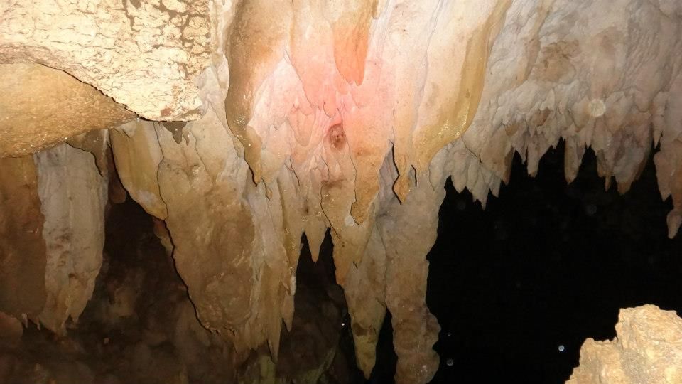
Despite the massive amount of vandalism, large sections of the cave still featured marvelous rock formations, flowstones, and stalagmites that are untouched. We hope that someday, we can give locals a lecture regarding the importance of preserving natural, delicate features such as these.

Rock Climbing in Poog

The cave’s main chamber has a ceiling that is so high that we can’t actually see the top. Human incursion must have driven the original inhabitants in this cave, probably some species of bats and birds.

Rock Climbing in Poog

On our way down, we stopped by a large opening in the cliff. We called this spot The Terrace, and it offered a nice view of farmlands and woodlands in the surrounding area. We could also see the gigantic Atlas Mining quarry in the distance.

Being several feet off the ground, the Terrace is a perfect vantage point for photographers who want to take good photos or videos of climbers in action without having to secure themselves around an anchor.

Rock Climbing in Poog

Below the Terrace, Ascamion and Enie set up some equipment in preparation for a climb.

Rock Climbing in Poog

Climbing the Crag

Willard had fun with some local kids who were curious as to what we’re doing here. Apparently, the presence of sweaty, ripped guys and pretty, sexy girls hauling ropes and wicked-looking equipment and climbing a high cliff is virtually unheard of here.

Rock Climbing in Poog

It was time to climb with Ascamion leading the way and with Enie as his belayer. Since the cliff is not bolted, we had to ascend it via trad climbing. Trad climbing is a rock climbing style in which a climber places cams, hexes, slings, and other gear that are needed to protect against falls. After the climb, all pieces of gear are removed.

Rock Climbing in Poog

Compare trad climbing to sport climbing (our style of climbing) in which all protection and anchor points are drilled and permanently installed on the route. Ascamion is the only one in our team with trad climbing experience and equipment, so he placed all the pros (protection) for the subsequent climbers.

Rock Climbing in Poog

While Ascamion climbed, the rest of the team took a relaxing break from caving at the belay area. Check out those cool, shy kids.

Rock Climbing in Poog

After several minutes, Ascamion finally reached an ideal point where he can place an anchor. That point is around 70 feet from the ground.

See that cavern way below Ascamion? The one with a patch of green? That’s The Terrace that we mentioned a while ago.

Rock Climbing in Poog

The super rock climbing team of Ascamion and Enie! Ascamion is a prolific and passionate Italian climber who has a lot of outdoor experience under his belt. He is into mountaineering, rock climbing, scuba diving, and more! A true blue adventurer indeed!

Enie, of course, is an experienced rock climbing guide in Cantabaco.

Rock Climbing in Poog

Then it was Sweetie’s turn to climb the route. Because it was our first time to do trad climbing, Ascamion advised us to climb the route top rope rather than leading it for safety reasons.

Rock Climbing in Poog

Go, Sweetie, go! Take a close look at the rock face in the photo below. You can see that there are lots of large handholds, footholds, and ledges, which makes climbing the route quite easy.

This is actually the kind of rock face that we are looking for, a rock face that is accessible, conducive, friendly, and relatively easy to ascend for first-timers and novice climbers.

Rock Climbing in Poog

That’s the belay area, which is rather small and narrow for a large crag and long crag. Also, there was an unpleasant and unmistakable waft of excrement in the air.

No worries though. When we get the go-signal from the property owners to develop the crag, we can ask and pay a few locals to clean the place and clear out the vegetation to expand the belay area.

Also, check out Sweetie; she’s got limestone dust all over her. The presence of limestone dust (product of natural erosion) means that this part of the cliff hasn’t been—or rarely—climbed before.

Rock Climbing in Poog

Then it was my turn to climb. The photo below shows just how high and large this cliff is. I’m miniscule compared to the size of that rock face.

Rock Climbing in Poog

We set up the route at the left side of the cliff. The right side is even more immense; the photo below shows just a tiny part of that side of the cliff. Also, check out the rock face. They’re full of holes, cracks, and slabs, which possibly make them easy and fun to climb.

A large, vegetation-covered crevice divides the two sides of the crag. Judging from its natural features, there may be a natural rock trail way inside the crevice so one can scramble all the way to the top of the cliff.

Rock Climbing in Poog

If I were to rate this route, which I feel is easier than the two easiest routes in Cantabaco, Hait and Vulva (both 5.8 in the YDS scale), it would be around 5.7. Thus, first-timers and novices who feel that climbing Hait and Vulva is still quite a challenge, then this crag is for them.

Hmmm…just blurting out the vain side of me: check out my back muscles! Hehehe! That’s the result of climbing.

Rock Climbing in Poog

After a few minutes, I reached the anchor and let out a whoop of triumph. In fact, I was beaming all the way down to the belay area.

Rock Climbing in Poog

Enie wanted a bit of a challenge so he lead climbed the route. Willard was his belayer.

Rock Climbing in Poog

Easy peasy for Enie! For hardcore, advanced rock climbers who prefer and are always on the hunt for the most challenging crags, you may find the Poog cliff a disappointment. However, you can always climb these rock faces to practice, build up endurance, or simply to have a break from all those tough crimpers, monos, pinches, and slopers.

Rock Climbing in Poog

Go, go, go, Enie! By the way, the two bolted, established routes are on the leftmost side of the crag. According to Sir Wendell Bagdhok, a professional Cebuano climber who was a member of the team that bolted the two routes, both routes are rated 5.11a. Hmmm…something that we want to chew on.

We couldn’t see the anchors of both routes from the belay station, so we did not risk climbing them. We need more information from the original team who bolted the routes.

Rock Climbing in Poog

Willard went inside the large crevice to check if there is a way to scramble up to the top without the use of ropes.

Rock Climbing in Poog

After everyone had their fill of climbing, Ascamion climbed up the route again to retrieve the protection gear. Again, he’s the only one who knows how to do this considering he’s the only one in the team who has trad climbing experiences.

We left the anchor in place for subsequent climbs.

Rock Climbing in Poog

On our way back to Cantabaco, we went to a nice vantage point in Media Once (a nearby barangay) where we saw a nice view of the Poog cliff. The cliff where we climbed is at the center right of the photo below.

As you can see, Toledo, Cebu has a huge potential in becoming a rock climbing destination in the Philippines.

Rock Climbing in Poog

We left Poog by noontime, had lunch on our way to Cantabaco, and worked on our Area 5 projects the entire afternoon.

Rock Climbing in Poog

Thank you so much, Enie, Willard, Ascamion, and Gretchen for inviting us to this exploration climb. At last, we found a crag that can truly inspire others to try out and enjoy the exciting sport of rock climbing. You have our full support in developing this crag. Let us begin!

Rock Climbing in Poog

Support Our Project, The Poog Crag Development

Hi bloggers, readers, followers, and friends! As part of our effort to make Cebu a world-class rock climbing destination, we are planning to bolt the Poog cliff for sport climbing. However, bolting rock climbing routes is quite a complicated matter in this part of the world, particularly because 1) it is expensive and 2) there are no suppliers of hangers and bolts here.

Help us promote sports tourism in Toledo as well as the sport of rock climbing. If you would like to help us in this endeavor, you can donate expansion bolts and hangers. 10 such bolts and hangers and 2 rappel hangers are needed to establish a single route. And as far as we know, the cliff can accommodate around 40 routes.

Check this link for information about climbing hangers and bolts. Photos of bolts, hangers, and rappel hangers (anchors at the top of the route) can be seen at the right side of the page.

In return for your generosity, we will name the bolted routes after you (or you can provide us any word, term, phrase, or name that you want).

Our coaches have specific parameters in mind. So please send us a message so we can give you the specs of what we need. Thank you.

Budget Per Person*

  • P 50 – non-aircon bus fare Cebu South Bus Terminal to Upper Poog-Toledo Highway crossing
  • P 10 – habal-habal fare from Upper Poog-Toledo Highway crossing to Upper Poog
  • P 10 – habal-habal fare from Upper Poog to Upper Poog-Toledo Highway crossing
  • P 50 – non-aircon bus fare from Upper Poog-Toledo Highway crossing to Cebu South Bus Terminal
  • P 100 – v-hire fare from Citilink Terminal to Upper Poog-Toledo Highway crossing. If you’re lucky, you can hail a V-hire coming from Toledo at the crossing. But most likely, V-hires passing by the crossing will be full. You need to ride a habal-habal or a bus that goes all the way to Toledo City. From Toledo, ride a v-hire that goes to the Citilink Terminal.
  • Guide fee – please negotiate with the local guides

* We did not include our expenses for meals, snacks, tips, and other fees in this rate sheet as you may have different needs, preferences, itineraries, miscellaneous transportation, and sharing scheme from us. Note that all figures are subject to change without prior notice.

Tips

1. Poog Cliff is very accessible. Take a Toledo-bound bus at the Cebu City South Bus Terminal. Ask the conductor to drop you off at the Upper Poog-Toledo Highway crossing at the left side of the highway. Your landmark is a sari-sari store called Rosita’s Store. Disembark from the bus, and take a habal-habal to Upper Poog.

You can see the cliff when you reach the unfinished part of the road. Get off at the gray, concrete house by the road.

2. Alternatively, you can take a V-hire at the Citilink Terminal in Cebu City rather than the bus. Once you get to the Poog crossing, follow the directions above.

3. Make sure you ask permission from the property custodian before climbing the cliff. The custodian resides in that grey, two-story concrete house beside the trail that leads to Poog cliff.

4. The Poog cliff is not yet developed for sport climbing save for two 5.11 bolted routes, which was installed by the original discoverers of the crag. Thus, for the moment, trad climbing is required to send the crag. Unfortunately, trad climbing is virtually non-existent here in Cebu.

If you really want to climb the crag, contact Cantabaco guides Enie Yonson (0948-7124875) or Willard Elimino (0947-9220289) so they can refer you to Ascamion Coimbra. In our circle of climber friends, only Ascamion has the experience and gear for trad climbing.

5. Ascamion is not a guide, but it is only prudent to give him some sort of honorarium for setting up the route for you. Negotiate the honorarium with Ascamion.

6. For trad climbers, bring a variety of cams and hexes. Also, you may want to bring several slings; the cliff has plenty of huecos (local guides call them through-and-throughs), holes that allow you to girth hitch a sling.

7. Bring your own rock climbing shoes, harness, and other equipment. If you don’t have them, you can rent equipment from the Cantabaco guides at affordable rates.

8. For your lunch and snacks, you can buy your food before heading to the cliff. There are a lot of stores and eateries nearby where you can buy your meals and drinks. It is quite exhausting if you have to go back down from the crag to buy lunch.

Or you can do it the way we did: we climbed the cliff in the morning then we returned to Cantabaco after lunch. We ate our lunch on the way to Cantabaco. You can eat your lunch at the carenderias at the Upper Poog-Toledo Highway crossing.

9. Unless you have a private vehicle, it is best to exit the crag early in the afternoon (around 3 PM) and head to the highway. This is especially true on Sundays. It will be difficult to catch a ride late in the afternoon because people from Toledo who are going back to the city to prepare for the work week will fill up buses and v-hires to the brim.

10. Together with the Cantabaco climbing team, we are making plans to develop the Poog cliff into a sport climbing crag. However, know that this may take quite some time as there are property issues, permits, negotiations, logistics, finance, and other aspects that need to be resolved and worked out before we can drill.

In the meantime, you can support this project by donating bolts, hangers, slings, and ropes. Please read the “Support Our Project, The Poog Crag Development” section above.

IMPORTANT NOTE:

Just because the photos look cool and fun does not mean that you can take climbing lightly. Climbing is inherently DANGEROUS! Every time you climb, your life and the life of your partner hang in the balance. There are only three things that will happen in climbing: you succeed, you get seriously injured, or you die. Your safety depends on you and SOLELY on you! Thus before you go out there, it is vitally important that you get some basic training on climbing principles, techniques, and safety first.

Visit a local indoor climbing gym to practice for a few sessions before heading out to the big rock wall. You should also get training from professional guides. Although blogs (including ours), books, tutorial videos, and articles could be a good source of information, you should find a certified climbing instructor to properly coach you through the sport. We got our training from Cantabaco’s guides and climbing instructors, and even if then, we’re still learning. Let us be clear on one thing: we are NOT climbing instructors.


Inambakan Falls: Natural Grandeur in Ginatilan, South Cebu

$
0
0
Aside from beautiful sandy beaches, Southern Cebu is a haven for some of the country’s most magnificent and pristine waterfalls, each with its own unique characteristic and grandeur. Many of these natural wonders are left in their pristine state even if they have become quite popular among Cebuanos. The mighty Inambakan Falls in the municipality […]

Mt. Hambubuyog: Revisiting and Rediscovering a Local Treasure

$
0
0
It is always a good feeling when you are that kid in the block who discovered something new or did the first of something. For us, mountaineers, discovering a new trail or mountain is our Holy Grail. And in 2011, we had our Grail. Together with my outdoor buddy Sir Ruel and a small team […]

Tumalog Falls: A Magical Gossamer Curtain in Oslob

$
0
0
One of the best things about our home province of Cebu is that our humble island is jam-packed with so many unique natural wonders. Come to think of it, each municipality has its own set of “specialty” attractions, and many more are still being discovered. Cebu is like a paradise of multiple facets. It’s no […]

Quiot to Toong to Jaclupan Trek: A Wilderness in the City

$
0
0
Metro Cebu is obviously a very well developed city. Highly urbanized, it offers locals and foreigners alike countless opportunities for work, living, and leisure. But just like in any highly urbanized metropolis in the world, something must inevitably give way. In most cases, it is nature that is forced to step aside. Cebu’s rapid growth […]
Viewing all 25 articles
Browse latest View live